
Carte topographique Pennington County
Carte interactive
Cliquez sur la carte pour afficher l’altitude.
À propos de cette carte
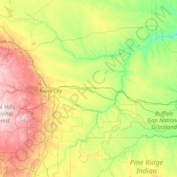
Nom : Carte topographique Pennington County, altitude, relief.
Lieu : Pennington County, South Dakota, United States (43.68494 -104.05545 44.50829 -102.00183)
Altitude moyenne : 960 m
Altitude minimum : 553 m
Altitude maximum : 2’186 m
Pennington County is located on the west line of South Dakota. Its west boundary line abuts the east boundary line of the state of Wyoming. Its west end contains the nation's highest peak east of the continental divide, Black Elk Peak. The rugged arid western end contains forest and gullies, descendending to rough rolling hill country in the east. The Cheyenne River flows north-northeastward through the center of the county and then along its northeastern border on its way to discharge in the Missouri River, while Rapid Creek flows east-southeastward through the western part, to discharge into the Cheyenne at the county's midpoint. The county terrain varies in elevation from Black Elk Peak at 7,242' (2207m) to its NE corner, at 1,896' (578m) ASL.
Autres cartes topographiques
Cliquez sur une carte pour visualiser sa topographie, son altitude et son relief.
Black Hills
United States > South Dakota > Pennington County
Black Hills, Pennington County, South Dakota, United States
Altitude moyenne : 1’894 m
Sage Creek Basin Overlook
United States > South Dakota > Pennington County
Sage Creek Basin Overlook, Rim Road, Pennington County, South Dakota, United States
Altitude moyenne : 869 m
Red Shirt Table
United States > South Dakota > Oglala Lakota County
Red Shirt Table, White Clay District, Oglala Lakota County, South Dakota, United States
Altitude moyenne : 932 m
Sage Creek
United States > South Dakota > Pennington County
Sage Creek, Pennington County, South Dakota, United States
Altitude moyenne : 865 m
Moon
United States > South Dakota > Pennington County
Moon, Pennington County, South Dakota, United States
Altitude moyenne : 1’938 m
Bridgewater
United States > South Dakota > McCook County
Bridgewater, Bridgewater Township, McCook County, South Dakota, United States
Altitude moyenne : 432 m
South Buttes Dam
United States > South Dakota > Harding County
South Buttes Dam, Harding County, South Dakota, United States
Altitude moyenne : 910 m
Duck Creek Dam Number 2
United States > South Dakota > Fall River County
Duck Creek Dam Number 2, Fall River County, South Dakota, United States
Altitude moyenne : 1’132 m
District 6
United States > South Dakota > Dewey County
District 6, Dewey County, South Dakota, 57652, United States
Altitude moyenne : 575 m
Mount Rushmore
United States > South Dakota > Pennington County
Mount Rushmore, Pennington County, South Dakota, 57751, United States
Altitude moyenne : 1’562 m
Rapid Creek
United States > South Dakota > Pennington County
Rapid Creek, Pennington County, South Dakota, United States
Altitude moyenne : 1’689 m
Harding County
Harding County, South Dakota, United States
Altitude moyenne : 930 m
Custer State Park
United States > South Dakota > Custer County
Custer State Park, Custer County, South Dakota, United States
Altitude moyenne : 1’413 m
Sanborn County
Sanborn County, South Dakota, United States
Altitude moyenne : 397 m
Lawrence County
Lawrence County, South Dakota, United States
Altitude moyenne : 1’506 m
Sturgis
United States > South Dakota > Meade County
Sturgis, Meade County, South Dakota, United States
Altitude moyenne : 1’127 m
Haakon County
Haakon County, South Dakota, 57553, United States
Altitude moyenne : 687 m
Hand County
Hand County, South Dakota, United States
Altitude moyenne : 500 m
Lincoln County
Lincoln County, South Dakota, United States
Altitude moyenne : 418 m
Buffalo County
Buffalo County, South Dakota, United States
Altitude moyenne : 520 m
Corson County
Corson County, South Dakota, United States
Altitude moyenne : 637 m
Miner County
Miner County, South Dakota, United States
Altitude moyenne : 456 m
District 2
United States > South Dakota > Ziebach County
District 2, Ziebach County, South Dakota, United States
Altitude moyenne : 710 m
Baltic
United States > South Dakota > Minnehaha County
Baltic, Sverdup Township, Minnehaha County, South Dakota, United States
Altitude moyenne : 454 m
Winner
United States > South Dakota > Tripp County
Winner, Tripp County, South Dakota, United States
Altitude moyenne : 609 m
Ree Township
United States > South Dakota > Charles Mix County
Ree Township, Charles Mix County, South Dakota, United States
Altitude moyenne : 441 m
De Smet
United States > South Dakota > Kingsbury County
De Smet, Kingsbury County, South Dakota, 57231, United States
Altitude moyenne : 525 m
Rapid City
United States > South Dakota > Pennington County
Rapid City, Pennington County, South Dakota, United States
Altitude moyenne : 1’068 m
Swett
United States > South Dakota > Bennett County
Swett, Pass Creek District, Bennett County, South Dakota, United States
Altitude moyenne : 1’029 m
Northeast Fall River
United States > South Dakota > Fall River County
Northeast Fall River, Fall River County, South Dakota, United States
Altitude moyenne : 1’033 m
Lakota Lake
United States > South Dakota > Custer County
Lakota Lake, Custer County, South Dakota, United States
Altitude moyenne : 1’409 m
Porcupine
United States > South Dakota > Oglala Lakota County
Porcupine, Porcupine District, Oglala Lakota County, South Dakota, 57772, United States
Altitude moyenne : 1’013 m
Mount Rushmore National Memorial
United States > South Dakota > Pennington County
Mount Rushmore National Memorial, Pennington County, South Dakota, United States
Altitude moyenne : 1’528 m
Madison
United States > South Dakota > Lake County
Madison, Lake County, South Dakota, United States
Altitude moyenne : 516 m
Terry Peak
United States > South Dakota > Lawrence County
Terry Peak, Lawrence County, South Dakota, United States
Altitude moyenne : 1’940 m
Badlands National Park
United States > South Dakota > Oglala Lakota County
Badlands National Park, Oglala Lakota County, South Dakota, 57750, United States
Altitude moyenne : 848 m
Aurora County
Aurora County, South Dakota, United States
Altitude moyenne : 479 m
Sioux Falls
United States > South Dakota > Minnehaha County
Sioux Falls, Sioux Falls Township, Minnehaha County, South Dakota, United States
Altitude moyenne : 445 m
Bourne Slough
United States > South Dakota > Lake County > Chautauqua
Bourne Slough, Chautauqua, Lake County, South Dakota, United States
Altitude moyenne : 496 m
Doland
United States > South Dakota > Spink County > Doland
Doland, Spink County, South Dakota, 57436, United States
Altitude moyenne : 416 m
Lyman County
Lyman County, South Dakota, United States
Altitude moyenne : 539 m
Wlliam T Malloy Dam
United States > South Dakota > Perkins County
Wlliam T Malloy Dam, Perkins County, South Dakota, United States
Altitude moyenne : 758 m
Olsonville
United States > South Dakota > Todd County > Olsonville
Olsonville, Todd County, South Dakota, United States
Altitude moyenne : 855 m
John Penor Dam
United States > South Dakota > Perkins County
John Penor Dam, Perkins County, South Dakota, 57620, United States
Altitude moyenne : 813 m
Moody County
United States > South Dakota > Moody County
Moody County, South Dakota, United States
Altitude moyenne : 498 m
Summit
United States > South Dakota > Roberts County > Summit
Summit, Roberts County, South Dakota, United States
Altitude moyenne : 609 m
Spearfish
United States > South Dakota > Lawrence County > Spearfish
Spearfish, Lawrence County, South Dakota, 57783, United States
Altitude moyenne : 1’291 m
Marshall County
Marshall County, South Dakota, United States
Altitude moyenne : 468 m
Watertown
United States > South Dakota > Codington County > Watertown
Watertown, Codington County, South Dakota, 57201, United States
Altitude moyenne : 550 m
Sisseton
United States > South Dakota > Roberts County > Sisseton
Sisseton, Long Hollow District, Roberts County, South Dakota, 57262, United States
Altitude moyenne : 381 m