
Faire un don
Équipez-vous pour votre prochaine aventure :
En tant que Partenaire Amazon, ce site perçoit une commission sur les achats éligibles sans surcoût pour vous.
Carte topographique Topock
Cliquez sur la carte pour afficher l’altitude.
Faire un don
Équipez-vous pour votre prochaine aventure :
En tant que Partenaire Amazon, ce site perçoit une commission sur les achats éligibles sans surcoût pour vous.
À propos de cette carte
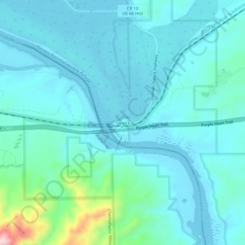
Nom : Carte topographique Topock, altitude, relief.
Lieu : Topock, Mohave County, Arizona, United States (34.69860 -114.50391 34.73860 -114.46391)
Altitude moyenne : 180 m
Altitude minimum : 137 m
Altitude maximum : 445 m
Faire un don
Équipez-vous pour votre prochaine aventure :
En tant que Partenaire Amazon, ce site perçoit une commission sur les achats éligibles sans surcoût pour vous.
Autres cartes topographiques
Cliquez sur une carte pour visualiser sa topographie, son altitude et son relief.
Hoover Dam
United States > Arizona > Mohave County
The amount of electricity generated by Hoover Dam has been decreasing along with the falling water level in Lake Mead due to the prolonged drought since year 2000 and high demand for the Colorado River's water. By 2014 its generating capacity was downrated by 23% to 1592 MW and was providing power only during…
Altitude moyenne : 429 m
Kingman
United States > Arizona > Mohave County
Lt. Edward Fitzgerald Beale, a U.S. Navy officer in the service of the Army Corps of Topographical Engineers, was ordered by the U.S. War Department to build a federal wagon road across the 35th parallel. His secondary orders were to test the feasibility of the use of camels as pack animals in the Southwestern…
Altitude moyenne : 1’130 m
Faire un don
Équipez-vous pour votre prochaine aventure :
En tant que Partenaire Amazon, ce site perçoit une commission sur les achats éligibles sans surcoût pour vous.
Bullhead City
United States > Arizona > Mohave County
Hardyville Pioneer Cemetery, a small cemetery, now a historic landmark at 35°7′16″N 114°35′17″W / 35.12111°N 114.58806°W / 35.12111; -114.58806, is the most significant existing remnant of Hardyville. An unofficial historical marker for the town is in the parking lot across Highway 95 from…
Altitude moyenne : 322 m
Bullhead City
United States > Arizona > Mohave County
Hardyville Pioneer Cemetery, a small cemetery, now a historic landmark at 35°7′16″N 114°35′17″W / 35.12111°N 114.58806°W / 35.12111; -114.58806, is the most significant existing remnant of Hardyville. An unofficial historical marker for the town is in the parking lot across Highway 95 from…
Altitude moyenne : 328 m
Faire un don
Équipez-vous pour votre prochaine aventure :
En tant que Partenaire Amazon, ce site perçoit une commission sur les achats éligibles sans surcoût pour vous.
Kingman
United States > Arizona > Mohave County
Lt. Edward Fitzgerald Beale, a U.S. Navy officer in the service of the Army Corps of Topographical Engineers, was ordered by the U.S. War Department to build a federal wagon road across the 35th parallel. His secondary orders were to test the feasibility of the use of camels as pack animals in the Southwestern…
Altitude moyenne : 1’131 m
Antares
United States > Arizona > Mohave County > Antares
Antares is located in northwestern Arizona, in central Mohave County, 21 miles (34 km) northeast of Kingman, the county seat. The Antares census-designated place encompasses 0.65 square miles (1.7 km2) of land, and is at 3,556 feet (1,084 m) elevation above sea level. The southern edge of the CDP follows State…
Altitude moyenne : 1’060 m
Faire un don
Équipez-vous pour votre prochaine aventure :
En tant que Partenaire Amazon, ce site perçoit une commission sur les achats éligibles sans surcoût pour vous.
Bullhead City
United States > Arizona > Mohave County
Hardyville Pioneer Cemetery, a small cemetery, now a historic landmark at 35°7′16″N 114°35′17″W / 35.12111°N 114.58806°W / 35.12111; -114.58806, is the most significant existing remnant of Hardyville. An unofficial historical marker for the town is in the parking lot across Highway 95 from…
Altitude moyenne : 322 m
Kingman
United States > Arizona > Mohave County
Lt. Edward Fitzgerald Beale, a U.S. Navy officer in the service of the Army Corps of Topographical Engineers, was ordered by the U.S. War Department to build a federal wagon road across the 35th parallel. His secondary orders were to test the feasibility of the use of camels as pack animals in the Southwestern…
Altitude moyenne : 1’131 m
Faire un don
Équipez-vous pour votre prochaine aventure :
En tant que Partenaire Amazon, ce site perçoit une commission sur les achats éligibles sans surcoût pour vous.
Faire un don
Équipez-vous pour votre prochaine aventure :
En tant que Partenaire Amazon, ce site perçoit une commission sur les achats éligibles sans surcoût pour vous.
Hoover Dam
United States > Arizona > Mohave County
The amount of electricity generated by Hoover Dam has been decreasing along with the falling water level in Lake Mead due to the prolonged drought in the 2010s and high demand for the Colorado River's water. Lake Mead fell to a new record low elevation of 1,071.61 feet (326.63 m) on July 1, 2016 before…
Altitude moyenne : 429 m
Hoover Dam
United States > Arizona > Mohave County
The amount of electricity generated by Hoover Dam has been decreasing along with the falling water level in Lake Mead due to the prolonged drought since year 2000 and high demand for the Colorado River's water. By 2014 its generating capacity was downrated by 23% to 1592 MW and was providing power only during…
Altitude moyenne : 429 m
Faire un don
Équipez-vous pour votre prochaine aventure :
En tant que Partenaire Amazon, ce site perçoit une commission sur les achats éligibles sans surcoût pour vous.
Kingman
United States > Arizona > Mohave County > Kingman
Lt. Edward Fitzgerald Beale, a U.S. Navy officer in the service of the U.S. Army Corps of Topographical Engineers, was ordered by the U.S. War Department to build a federal wagon road across the 35th Parallel. His secondary orders were to test the feasibility of the use of camels as pack animals in the…
Altitude moyenne : 1’135 m
Faire un don
Équipez-vous pour votre prochaine aventure :
En tant que Partenaire Amazon, ce site perçoit une commission sur les achats éligibles sans surcoût pour vous.