
Carte topographique Suez Canal
Carte interactive
Cliquez sur la carte pour afficher l’altitude.
À propos de cette carte
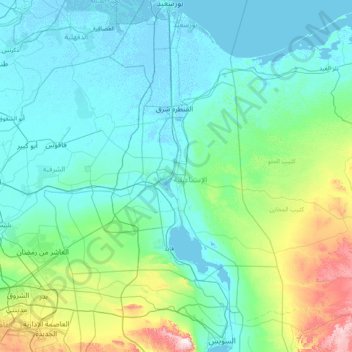
Nom : Carte topographique Suez Canal, altitude, relief.
Lieu : Suez Canal, Port Said, 43522, Egypt (29.93034 32.30378 31.27571 32.58750)
Altitude moyenne : 106 m
Altitude minimum : -6 m
Altitude maximum : 869 m
Although the alleged difference in sea levels could be problematic for construction, the idea of finding a shorter route to the east remained alive. In 1830, F. R. Chesney submitted a report to the British government that stated that there was no difference in elevation and that the Suez Canal was feasible, but his report received no further attention. Lieutenant Waghorn established his "Overland Route", which transported post and passengers to India via Egypt.
Autres cartes topographiques
Cliquez sur une carte pour visualiser sa topographie, son altitude et son relief.
Al-ʿAbbāsiyyah Canal
Al-ʿAbbāsiyyah Canal, Port Said, 41524, Egypt
Altitude moyenne : 16 m