
Carte topographique Rhynd
Carte interactive
Cliquez sur la carte pour afficher l’altitude.
À propos de cette carte
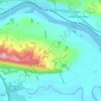
Nom : Carte topographique Rhynd, altitude, relief.
Altitude moyenne : 40 m
Altitude minimum : -2 m
Altitude maximum : 219 m
Autres cartes topographiques
Cliquez sur une carte pour visualiser sa topographie, son altitude et son relief.
Elcho Castle
United Kingdom > Scotland > Perth and Kinross > Perth > Rhynd
Elcho Castle, Rhynd, Perth, Perth and Kinross, Scotland, PH2 8QQ, United Kingdom
Altitude moyenne : 38 m
Kinfauns
United Kingdom > Scotland > Perth and Kinross > Perth
Kinfauns, Perth, Perth and Kinross, Scotland, PH2 7LD, United Kingdom
Altitude moyenne : 83 m
Dupplin Loch
United Kingdom > Scotland > Perth and Kinross > Perth
Dupplin Loch, Perth, Perth and Kinross, Scotland, United Kingdom
Altitude moyenne : 130 m