
Carte topographique Smithfield
Carte interactive
Cliquez sur la carte pour afficher l’altitude.
À propos de cette carte
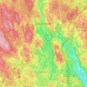
Nom : Carte topographique Smithfield, altitude, relief.
Lieu : Smithfield, Providence County, Rhode Island, United States (41.85860 -71.59025 41.94388 -71.46688)
Altitude moyenne : 107 m
Altitude minimum : 27 m
Altitude maximum : 179 m
Autres cartes topographiques
Cliquez sur une carte pour visualiser sa topographie, son altitude et son relief.
Cumberland
United States > Rhode Island > Providence County
Cumberland, Providence County, Rhode Island, 02864, United States
Altitude moyenne : 76 m
Chopmist
United States > Rhode Island > Providence County > Scituate
Chopmist, Scituate, Providence County, Rhode Island, 02857, United States
Altitude moyenne : 175 m
Diamond Hill
United States > Rhode Island > Providence County > Cumberland
Diamond Hill, Cumberland, Providence County, Rhode Island, 02864, United States
Altitude moyenne : 80 m
Providence
United States > Rhode Island > Providence County
Providence, Providence County, Rhode Island, United States
Altitude moyenne : 19 m
Cranston
United States > Rhode Island > Providence County
Cranston, Providence County, Rhode Island, United States
Altitude moyenne : 27 m
East Providence
United States > Rhode Island > Providence County
East Providence, Providence County, Rhode Island, United States
Altitude moyenne : 12 m
James V. Turner Reservoir
United States > Rhode Island > Providence County > East Providence > Rumford
James V. Turner Reservoir, Rumford, East Providence, Providence County, Rhode Island, United States
Altitude moyenne : 14 m
Page Island
United States > Rhode Island > Providence County > Pascoag
Page Island, Pascoag, Providence County, Rhode Island, 02859, United States
Altitude moyenne : 124 m
Pawtucket
United States > Rhode Island > Providence County
Pawtucket, Providence County, Rhode Island, United States
Altitude moyenne : 24 m
Central Falls
United States > Rhode Island > Providence County
Central Falls, Providence County, Rhode Island, United States
Altitude moyenne : 22 m
Roosevelt Lake
United States > Rhode Island > Providence County > Providence
Roosevelt Lake, Providence, Providence County, Rhode Island, United States
Altitude moyenne : 12 m
North Providence
United States > Rhode Island > Providence County
North Providence, Providence County, Rhode Island, 02911, United States
Altitude moyenne : 53 m
Woonsocket
United States > Rhode Island > Providence County
Woonsocket, Providence County, Rhode Island, 02895, United States
Altitude moyenne : 74 m
Cunliff Pond Dam
United States > Rhode Island > Providence County > Providence
Cunliff Pond Dam, Providence, Providence County, Rhode Island, 02905, United States
Altitude moyenne : 9 m
Providence River
United States > Rhode Island > Providence County > Providence
Providence River, Providence, Providence County, Rhode Island, 02903, United States
Altitude moyenne : 9 m
North Smithfield
United States > Rhode Island > Providence County > North Smithfield
North Smithfield, Providence County, Rhode Island, United States
Altitude moyenne : 96 m
Burrillville
United States > Rhode Island > Providence County
Burrillville, Providence County, Rhode Island, United States
Altitude moyenne : 155 m
Saylesville
United States > Rhode Island > Providence County > Lincoln
Saylesville, Lincoln, Providence County, Rhode Island, 02863, United States
Altitude moyenne : 37 m
Town Line Swamp
United States > Rhode Island > Providence County > Lincoln
Town Line Swamp, Lincoln, Providence County, Rhode Island, United States
Altitude moyenne : 110 m
Glocester
United States > Rhode Island > Providence County
Glocester, Providence County, Rhode Island, United States
Altitude moyenne : 166 m
Valley Falls
United States > Rhode Island > Providence County > Cumberland
Valley Falls, Cumberland, Providence County, Rhode Island, 02863, United States
Altitude moyenne : 28 m
Chepachet
United States > Rhode Island > Providence County > Glocester
Chepachet, Glocester, Providence County, Rhode Island, 02814, United States
Altitude moyenne : 144 m
Olneyville
United States > Rhode Island > Providence County > Providence
Olneyville, Providence, Providence County, Rhode Island, 02909, United States
Altitude moyenne : 24 m
Lincoln
United States > Rhode Island > Providence County
Lincoln, Providence County, Rhode Island, United States
Altitude moyenne : 82 m