
Carte topographique Moros
Carte interactive
Cliquez sur la carte pour afficher l’altitude.
À propos de cette carte
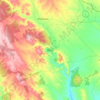
Nom : Carte topographique Moros, altitude, relief.
Lieu : Moros, Comunidad de Calatayud, Zaragoza, Aragon, Spain (41.36687 -1.91315 41.42871 -1.75219)
Altitude moyenne : 777 m
Altitude minimum : 586 m
Altitude maximum : 1’013 m
Moros is one of the most attractive and picturesque villages of its kind in the area. Its narrow streets zigzag from the square at its highest elevation down to the river bed below. The houses are the main feature of the town. Hundreds of houses have been built tightly against the sunny side of the mountain. They are built with mud and decorated with red and ochre Arabic tiles. Each level of houses rises above the one beneath it to catch the sun as it rises over the valley.
Autres cartes topographiques
Cliquez sur une carte pour visualiser sa topographie, son altitude et son relief.
Calatayud
Spain > Aragon > Comunidad de Calatayud
Calatayud, Comunidad de Calatayud, Zaragoza, Aragon, 50300, Spain
Altitude moyenne : 693 m
Ariza
Spain > Aragon > Comunidad de Calatayud
Ariza, Comunidad de Calatayud, Zaragoza, Aragon, 50220, Spain
Altitude moyenne : 801 m
Mara
Spain > Aragon > Comunidad de Calatayud
Mara, Comunidad de Calatayud, Zaragoza, Aragon, Spain
Altitude moyenne : 773 m
Alhama de Aragón
Spain > Aragon > Comunidad de Calatayud > Alhama de Aragón
Alhama de Aragón, Comunidad de Calatayud, Zaragoza, Aragon, Spain
Altitude moyenne : 763 m