
Faire un don
Équipez-vous pour votre prochaine aventure :
En tant que Partenaire Amazon, ce site perçoit une commission sur les achats éligibles sans surcoût pour vous.
Carte topographique Kyzyl
Cliquez sur la carte pour afficher l’altitude.
Faire un don
Équipez-vous pour votre prochaine aventure :
En tant que Partenaire Amazon, ce site perçoit une commission sur les achats éligibles sans surcoût pour vous.
Kyzyl
They began to lay a new city in the village of Vilany, in Tuvan – Khem-Beldyr, which means "confluence of rivers". Technological engineer K.V. Goguntsov and topographer M. Ya. Kryuchkov arrived here in February 1914. Kryuchkov drew a general plan of the city of Belotsarsk (fund 123, opis, 2, delo 21), which basically coincides with the plan of the central part of the city of Kyzyl. The city plan shows the numbers of the land plots and gives an explanation of who owns these plots. In May 1914, the head of the Russian population in Uryankhai approved the draft rules on the allotment of land plots and the organization of a committee for the improvement of the future city. The very first plots were allocated for houses of officials, administration, for honorary Uryankhs, treasury, post and telegraph office, state fire shed.
Faire un don
Équipez-vous pour votre prochaine aventure :
En tant que Partenaire Amazon, ce site perçoit une commission sur les achats éligibles sans surcoût pour vous.
À propos de cette carte
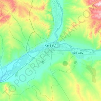
Nom : Carte topographique Kyzyl, altitude, relief.
Altitude moyenne : 799 m
Altitude minimum : 600 m
Altitude maximum : 1’547 m
Faire un don
Équipez-vous pour votre prochaine aventure :
En tant que Partenaire Amazon, ce site perçoit une commission sur les achats éligibles sans surcoût pour vous.