Géolocaliser

Carte topographique Uplyme

Cliquez sur la carte pour afficher l’altitude.

À propos de cette carte

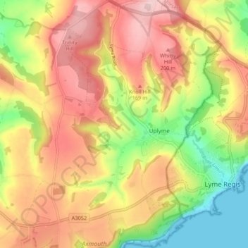
Nom : Carte topographique Uplyme, altitude, relief.

Lieu : Uplyme, East Devon, Devon, Devon and Torbay, England, United Kingdom (50.71196 -2.98956 50.76368 -2.93506)

Altitude moyenne : 121 m

Altitude minimum : 0 m

Altitude maximum : 225 m

👉 Easily get elevation data in JSON, GeoTIFF and KML formats using Elevation API
Merci de soutenir ce site ❤️
Faire un don

Équipez-vous pour votre prochaine aventure :

En tant que Partenaire Amazon, ce site perçoit une commission sur les achats éligibles sans surcoût pour vous.

Autres cartes topographiques

Cliquez sur une carte pour visualiser sa topographie, son altitude et son relief.

Hooken Cliffs

United Kingdom > England > Devon > East Devon

Altitude moyenne : 35 m

Orcombe Point

United Kingdom > England > Devon > East Devon > Exmouth

Altitude moyenne : 16 m

Woodbridge

United Kingdom > England > Devon > East Devon > Farway

Altitude moyenne : 140 m

Holyford

United Kingdom > England > Devon > East Devon > Seaton

Altitude moyenne : 65 m

Rousdon

United Kingdom > England > Devon > East Devon

Altitude moyenne : 100 m

Holyford

United Kingdom > England > Devon > East Devon > Seaton

Altitude moyenne : 65 m

Fluxton

United Kingdom > England > Devon > East Devon > Tipton St John

Altitude moyenne : 74 m

Broadclyst

United Kingdom > England > Devon > East Devon

Altitude moyenne : 30 m

Sandy Bay

United Kingdom > England > Devon > East Devon > Exmouth

Altitude moyenne : 20 m

Yettington

United Kingdom > England > Devon > East Devon

Altitude moyenne : 67 m

Knowle

United Kingdom > England > Devon > East Devon

Altitude moyenne : 54 m

Seaton Beach

United Kingdom > England > Devon > East Devon > Seaton > Beer

Altitude moyenne : 35 m

The Clump

United Kingdom > England > Devon > East Devon

Altitude moyenne : 45 m

Holcombe

United Kingdom > England > Devon > East Devon > Uplyme

Altitude moyenne : 124 m

Rewe

United Kingdom > England > Devon > East Devon

Altitude moyenne : 34 m

Sector

United Kingdom > England > Devon > East Devon > Axminster

Altitude moyenne : 102 m

Yettington

United Kingdom > England > Devon > East Devon

Altitude moyenne : 67 m

Yawl

United Kingdom > England > Devon > East Devon > Uplyme > Hoyton

Altitude moyenne : 146 m

Millhayes

United Kingdom > England > Devon > East Devon > Stockland

Altitude moyenne : 145 m

Whitford

United Kingdom > England > Devon > East Devon

Altitude moyenne : 43 m

Netherexe

United Kingdom > England > Devon > East Devon > Rewe

Altitude moyenne : 36 m

Wilmington

United Kingdom > England > Devon > East Devon

Altitude moyenne : 149 m

Rockbeare

United Kingdom > England > Devon > East Devon

Altitude moyenne : 39 m

Golden Square

United Kingdom > England > Devon > East Devon > Stockland

Altitude moyenne : 162 m

Ebford

United Kingdom > England > Devon > East Devon

Altitude moyenne : 20 m

Woodbury Salterton

United Kingdom > England > Devon > East Devon

Altitude moyenne : 65 m

Furley

United Kingdom > England > Devon > East Devon > Membury

Altitude moyenne : 143 m

Godford Cross

United Kingdom > England > Devon > East Devon > Awliscombe

Altitude moyenne : 141 m

Marsh Green

United Kingdom > England > Devon > East Devon > Marsh Green

Altitude moyenne : 83 m

Cloakham

United Kingdom > England > Devon > East Devon > Axminster > Cloakham

Altitude moyenne : 68 m

Allercombe

United Kingdom > England > Devon > East Devon > Marsh Green > Allercombe

Altitude moyenne : 90 m

Luton

United Kingdom > England > Devon > East Devon > Colliton

Altitude moyenne : 104 m

Weycroft

United Kingdom > England > Devon > East Devon > Axminster > Weycroft

Altitude moyenne : 77 m

Widworthy

United Kingdom > England > Devon > East Devon > Wilmington

Altitude moyenne : 140 m

Équipez-vous pour votre prochaine aventure :

🧺Couverture de survie - Équipement de sécurité vital pour prévenir l'hypothermie
🔋Piles rechargeables - Économiques et écologiques pour vos appareils nomades
🔦Lampes frontales - Éclairage mains libres pour randonnée et bivouac
📟GPS de randonnée - L'outil indispensable pour suivre vos tracés et coordonnées en haute altitude
🧭Boussoles d’orientation - Boussoles fiables pour navigation terrestre et lecture de cartes

En tant que Partenaire Amazon, ce site perçoit une commission sur les achats éligibles sans surcoût pour vous.