
Carte topographique Gyachung Kang
Carte interactive
Cliquez sur la carte pour afficher l’altitude.
À propos de cette carte
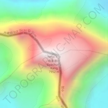
Nom : Carte topographique Gyachung Kang, altitude, relief.
Altitude moyenne : 7’006 m
Altitude minimum : 6’228 m
Altitude maximum : 7’932 m
Autres cartes topographiques
Cliquez sur une carte pour visualiser sa topographie, son altitude et son relief.
Cho Oyu
Nepal > Solukhumbu > Khumjung
Cho Oyu, Khumjung, Khumbupasanglahmu, Solukhumbu, Koshi Province, Nepal
Altitude moyenne : 7’339 m