Géolocaliser

Carte topographique Bardhaman

Cliquez sur la carte pour afficher l’altitude.

Bardhaman

The region has an average elevation of 40 metres (131 ft). The city is situated 1100 km from New Delhi and a little less than 100 km north-west of Kolkata on the Grand Trunk Road (National Highway 19) and Eastern Railway. The chief rivers are the Damodar and the Banka.

À propos de cette carte

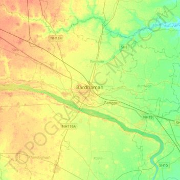
Nom : Carte topographique Bardhaman, altitude, relief.

Lieu : Bardhaman, Burdwan - I, Paschim Bardhaman, West Bengal, 713102, India (23.08957 87.70818 23.40957 88.02818)

Altitude moyenne : 30 m

Altitude minimum : 14 m

Altitude maximum : 45 m

Équipez-vous pour votre prochaine aventure :

🎿Housse de transport skis - Protégez votre matériel lors de vos déplacements en train ou voiture
🏕️Tentes de randonnée - Tentes légères pour bivouac et trekking
🥤Paille filtrante / Gourde - Buvez l'eau des torrents en toute sécurité grâce à la filtration
🏞️Jumelles compactes - Observation en nature
🔪Couteaux de survie - Outils robustes pour activités outdoor

En tant que Partenaire Amazon, ce site perçoit une commission sur les achats éligibles sans surcoût pour vous.