
Carte topographique Kecamatan Pangkalan Kerinci
Carte interactive
Cliquez sur la carte pour afficher l’altitude.
À propos de cette carte
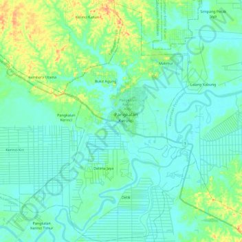
Nom : Carte topographique Kecamatan Pangkalan Kerinci, altitude, relief.
Altitude moyenne : 14 m
Altitude minimum : 1 m
Altitude maximum : 63 m
Autres cartes topographiques
Cliquez sur une carte pour visualiser sa topographie, son altitude et son relief.
Tanah Datar
Indonésie > Riau > Rokan Hulu
Tanah Datar, Kecamatan Kunto Darussalam, Rokan Hulu, Riau, Sumatra, Indonésie
Altitude moyenne : 40 m
Tanah Datar
Indonésie > Riau > Tanah Datar
Tanah Datar, Kecamatan Rengat Barat, Kabupaten Indragiri Hulu, Riau, Indonésie
Altitude moyenne : 56 m
Pangkalan Kerinci
Indonésie > Riau > Pangkalan Kerinci
Pangkalan Kerinci, Kabupaten Pelalawan, Riau, Indonésie
Altitude moyenne : 9 m