
Faire un don
Équipez-vous pour votre prochaine aventure :
En tant que Partenaire Amazon, ce site perçoit une commission sur les achats éligibles sans surcoût pour vous.
Carte topographique Dilla
Cliquez sur la carte pour afficher l’altitude.
Faire un don
Équipez-vous pour votre prochaine aventure :
En tant que Partenaire Amazon, ce site perçoit une commission sur les achats éligibles sans surcoût pour vous.
Dilla
Dilla (Amharic: ዲላ) is a market town and separate woreda in southern Ethiopia. The administrative center of the Gedeo Zone in the former Southern Nations, Nationalities, and Peoples Region (SNNPR) now it is South Ethiopia Regional State (SER), it is located on the main road from Addis Ababa to Nairobi. The town has a longitude and latitude of 6°24′30″N 38°18′30″E / 6.40833°N 38.30833°E / 6.40833; 38.30833, with an elevation of 1570 meters above sea level. It was part of Wenago woreda and is currently surrounded by Dilla Zuria woreda.
Faire un don
Équipez-vous pour votre prochaine aventure :
En tant que Partenaire Amazon, ce site perçoit une commission sur les achats éligibles sans surcoût pour vous.
À propos de cette carte
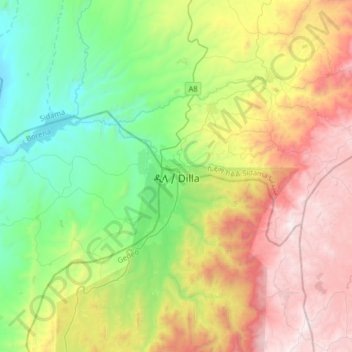
Nom : Carte topographique Dilla, altitude, relief.
Lieu : Dilla, Gedeo, South Ethiopia Regional State, Ethiopia (6.24996 38.15028 6.56996 38.47028)
Altitude moyenne : 1’886 m
Altitude minimum : 1’183 m
Altitude maximum : 3’010 m
Faire un don
Équipez-vous pour votre prochaine aventure :
En tant que Partenaire Amazon, ce site perçoit une commission sur les achats éligibles sans surcoût pour vous.
Autres cartes topographiques
Cliquez sur une carte pour visualiser sa topographie, son altitude et son relief.
Nech Sar National Park
Ethiopia > South Ethiopia Regional State > Arba Minch
Altitude moyenne : 1’215 m
Bombe
Ethiopia > South Ethiopia Regional State
Bombe (Geʽez: ቦምቤ) is a town and separate district in Wolayita Zone of the South Ethiopia Regional State, Ethiopia. Bombe town is located 325 km (202 mi) and 55 km (34 mi) away from Addis Ababa and Wolaita Sodo town through Hossana exit, respectively. Bombe town is used as an administrative capital of…
Altitude moyenne : 1’517 m
Boditi
Ethiopia > South Ethiopia Regional State
Boditi, (Amharic: ቦዲቲ) or (Wolayttattuwa: Bodditte) is a city and separate district in south central Ethiopia. The city is located in the Wolaita Zone of the South Ethiopia Regional State. This city has a latitude and longitude of 6°58′N 37°52′E / 6.967°N 37.867°E / 6.967; 37.867 with an…
Altitude moyenne : 1’982 m