Géolocaliser

Carte topographique Saba

Carte interactive

Cliquez sur la carte pour afficher l’altitude.

À propos de cette carte

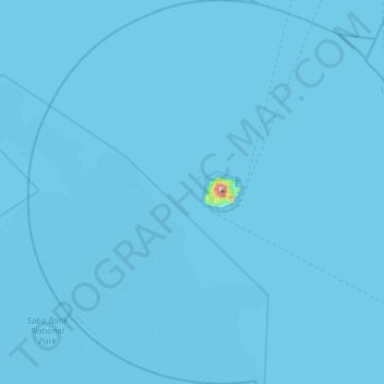
Nom : Carte topographique Saba, altitude, relief.

Lieu : Saba, Netherlands (17.41400 -63.46882 17.85000 -63.02603)

Altitude moyenne : 2 m

Altitude minimum : 0 m

Altitude maximum : 834 m

There is an 8.6 hectares (21 acres) cloud forest located at and above 825 metres (2,707 ft) on top of the mountain referred to as the "Elfin Forest Reserve" because of its high altitude mist and mossy appearance. The most dominant tree in the cloud forest is the Mountain Mahogany (Freziera undulate), although hurricanes over the years have destroyed a large number of the mature trees. Despite the name, the mountain mahogany is not related to other mahogany species; although one species of true mahogany tree is found on the island at lower levels, the small-leaved mahogany (Swietenia mahagoni). In the underbrush of the mahogany trees, the Sierran palm (Prestoea montana) and tree ferns dominate, with a large variety of epiphytes and Orchids growing on the trunks and branches of all the trees. Wild raspberries and plantain trees can also be found growing on most of the mountain. All seven of the Lesser Antilles Endemic Bird Area restricted-range birds occur in the Elfin Forest Reserve.

Wikipedia (CC-BY-SA 3.0)

Autres cartes topographiques

Cliquez sur une carte pour visualiser sa topographie, son altitude et son relief.

Hengelo

Netherlands > Overijssel

Hengelo, Overijssel, Netherlands

Altitude moyenne : 23 m

Bunschoten-Spakenburg

Netherlands > Utrecht

Bunschoten-Spakenburg, Bunschoten, Utrecht, Netherlands

Altitude moyenne : 0 m

Curacao

Netherlands

Curacao, Netherlands

Altitude moyenne : 2 m

Amsterdam

Netherlands > North Holland

Amsterdam, North Holland, Netherlands

Altitude moyenne : 0 m

Holland

Netherlands

Holland, Netherlands

Altitude moyenne : 2 m

Wanssum

Netherlands > Limburg

Wanssum, Venray, Limburg, Netherlands

Altitude moyenne : 18 m

Bilthoven

Netherlands > Utrecht

Bilthoven, De Bilt, Utrecht, Netherlands

Altitude moyenne : 5 m

Someren

Netherlands > North Brabant

Someren, North Brabant, Netherlands

Altitude moyenne : 26 m

Zeeland

Netherlands

Zeeland, Netherlands

Altitude moyenne : 1 m

Aruba

Netherlands > Santa Cruz

Aruba, Santa Cruz, Aruba, ARUBA, Netherlands

Altitude moyenne : 1 m

Utrecht

Netherlands > Utrecht

Utrecht, Netherlands

Altitude moyenne : 3 m

Geldrop

Netherlands > North Brabant

Geldrop, Geldrop-Mierlo, North Brabant, Netherlands

Altitude moyenne : 21 m

Renswoude

Netherlands > Utrecht

Renswoude, Utrecht, Netherlands

Altitude moyenne : 8 m

Koudekerke

Netherlands > Zeeland

Koudekerke, Veere, Zeeland, Netherlands

Altitude moyenne : 0 m

Overberg

Netherlands > Utrecht

Overberg, Utrechtse Heuvelrug, Utrecht, Netherlands

Altitude moyenne : 17 m

Didam

Netherlands > Gelderland

Didam, Montferland, Gelderland, Netherlands

Altitude moyenne : 12 m

Scheemda

Netherlands > Groningen

Scheemda, Oldambt, Groningen, Netherlands

Altitude moyenne : 0 m

Veluwe

Netherlands > Gelderland

Veluwe, Gelderland, Netherlands

Altitude moyenne : 18 m

Veendam

Netherlands > Groningen

Veendam, Groningen, Netherlands

Altitude moyenne : 3 m

Zwanenburg

Netherlands > North Holland

Zwanenburg, Haarlemmermeer, North Holland, Netherlands

Altitude moyenne : -3 m

Cottessen

Netherlands > Limburg > Vijlen

Cottessen, Vijlen, Vaals, Limburg, Netherlands, 6294 NE, Netherlands

Altitude moyenne : 183 m

Kessel

Netherlands > Limburg

Kessel, Peel en Maas, Limburg, Netherlands

Altitude moyenne : 27 m

Overheek

Netherlands > Limburg > Termaar

Overheek, Termaar, Klimmen, Voerendaal, Limburg, Netherlands, 6343 DB, Netherlands

Altitude moyenne : 118 m

America

Netherlands > Limburg

America, Horst aan de Maas, Limburg, Netherlands

Altitude moyenne : 31 m

Berkhoek

Netherlands > North Brabant > Udenhout

Berkhoek, Udenhout, Tilburg, North Brabant, Netherlands, 5071 NE, Netherlands

Altitude moyenne : 11 m

Eemshaven

Netherlands > Groningen

Eemshaven, Het Hogeland, Groningen, Netherlands

Altitude moyenne : 0 m

Leiden

Netherlands > South Holland

Leiden, South Holland, Netherlands

Altitude moyenne : 1 m

Volendam

Netherlands > North Holland

Volendam, Edam-Volendam, North Holland, Netherlands

Altitude moyenne : 0 m

Leiden

Netherlands > South Holland

Leiden, South Holland, Netherlands

Altitude moyenne : 1 m

Flevoland

Netherlands

Flevoland, Netherlands

Altitude moyenne : 1 m

Ameland

Netherlands > Frisia

Ameland, Frisia, Netherlands

Altitude moyenne : 0 m

Wageningen

Netherlands > Gelderland

Wageningen, Gelderland, Netherlands

Altitude moyenne : 13 m

Groesbeek

Netherlands > Gelderland

Groesbeek, Berg en Dal, Gelderland, Netherlands

Altitude moyenne : 41 m

Vinkeveen

Netherlands > Utrecht

Vinkeveen, De Ronde Venen, Utrecht, Netherlands

Altitude moyenne : -3 m

Maastricht

Netherlands > Limburg

Maastricht, Limburg, Netherlands

Altitude moyenne : 73 m

Eenrum

Netherlands > Groningen

Eenrum, Het Hogeland, Groningen, Netherlands

Altitude moyenne : 0 m

Maaskantje

Netherlands > North Brabant

Maaskantje, Sint-Michielsgestel, North Brabant, Netherlands, 5271 XG, Netherlands

Altitude moyenne : 6 m

North Brabant

Netherlands

North Brabant, Netherlands

Altitude moyenne : 99 m

Oosterhout

Netherlands > North Brabant

Oosterhout, North Brabant, Netherlands

Altitude moyenne : 4 m

Mook

Netherlands > Limburg

Mook, Mook en Middelaar, Limburg, Netherlands

Altitude moyenne : 29 m

Zuidland

Netherlands > South Holland

Zuidland, Nissewaard, South Holland, Netherlands

Altitude moyenne : 0 m

Slingeplas

Netherlands > Gelderland > Bredevoort

Slingeplas, Bredevoort, Aalten, Gelderland, Netherlands

Altitude moyenne : 29 m

Veldhoek

Netherlands > Gelderland

Veldhoek, Hengelo (Gld), Bronckhorst, Gelderland, Netherlands, 7255 NH, Netherlands

Altitude moyenne : 18 m

Franeker

Netherlands > Frisia

Franeker, Waadhoeke, Frisia, Netherlands

Altitude moyenne : 0 m

Ellecom

Netherlands > Gelderland

Ellecom, Rheden, Gelderland, Netherlands

Altitude moyenne : 21 m

Amersfoort

Netherlands > Utrecht

Amersfoort, Utrecht, Netherlands

Altitude moyenne : 7 m

Maassluis

Netherlands > South Holland

Maassluis, South Holland, Netherlands

Altitude moyenne : 2 m

Rotterdam

Netherlands > South Holland

Rotterdam, South Holland, Netherlands

Altitude moyenne : 0 m

Gilze

Netherlands > North Brabant

Gilze, Gilze en Rijen, North Brabant, Netherlands

Altitude moyenne : 15 m

Bonaire

Netherlands

Bonaire, Netherlands

Altitude moyenne : 1 m