
Carte topographique Hojai
Carte interactive
Cliquez sur la carte pour afficher l’altitude.
À propos de cette carte
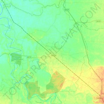
Nom : Carte topographique Hojai, altitude, relief.
Lieu : Hojai, Assam, 782435, India (25.90907 92.73311 26.10897 92.92571)
Altitude moyenne : 71 m
Altitude minimum : 60 m
Altitude maximum : 88 m
Autres cartes topographiques
Cliquez sur une carte pour visualiser sa topographie, son altitude et son relief.
Jorhat
India > Assam > Jorhat East
Jorhat, Jorhat East, Jorhat District, Assam, 785001, India
Altitude moyenne : 93 m
Kaziranga National Park and Tiger Reserve
Kaziranga National Park and Tiger Reserve, Bokakhat, Golaghat District, Assam, India
Altitude moyenne : 202 m
North Lakhimpur
North Lakhimpur, Lakhimpur, Assam, India
Altitude moyenne : 96 m
Numaligarh
India > Assam > Bokakhat > Numaligarh
Numaligarh, Bokakhat, Golaghat, Assam, 785615, India
Altitude moyenne : 87 m
Mahatma Gandhi Park
Mahatma Gandhi Park, Chowk Bazar, Atila Gaon, Jorhat, Assam, India
Altitude moyenne : 92 m