
Carte topographique Abu Road
Carte interactive
Cliquez sur la carte pour afficher l’altitude.
À propos de cette carte
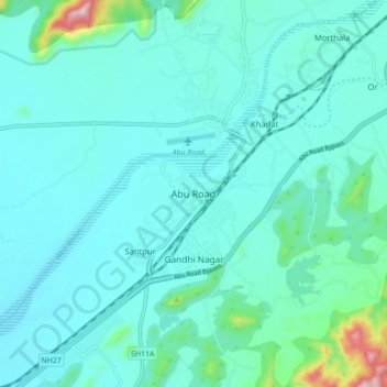
Nom : Carte topographique Abu Road, altitude, relief.
Altitude moyenne : 287 m
Altitude minimum : 234 m
Altitude maximum : 631 m
Autres cartes topographiques
Cliquez sur une carte pour visualiser sa topographie, son altitude et son relief.
Oriya
India > Rajasthan > Abu Road Tehsil
Oriya, Abu Road Tehsil, Sirohi District, Rajasthan, 307501, India
Altitude moyenne : 1’304 m
Aravalli Range
India > Rajasthan > Abu Road Tehsil
Aravalli Range, Abu Road Tehsil, Sirohi District, Rajasthan, 307501, India
Altitude moyenne : 1’339 m