
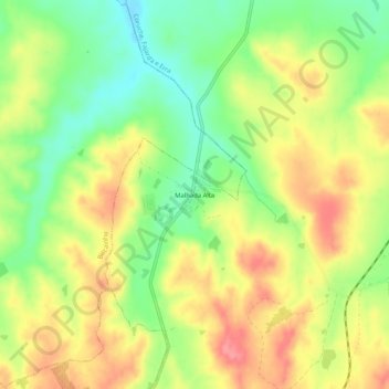
Carte topographique Malhada Alta
Carte interactive
Cliquez sur la carte pour afficher l’altitude.
À propos de cette carte
Nom : Carte topographique Malhada Alta, altitude, relief.
Altitude moyenne : 66 m
Altitude minimum : 25 m
Altitude maximum : 105 m
Autres cartes topographiques
Cliquez sur une carte pour visualiser sa topographie, son altitude et son relief.
Ovelhas
Portugal > Santarém > Coruche > São José da Lamarosa
Ovelhas, São José da Lamarosa, Coruche, Santarém, Portugal
Altitude moyenne : 86 m
Santo Antonino
Santo Antonino, Coruche, Fajarda e Erra, Coruche, Santarém, 2100-042, Portugal
Altitude moyenne : 48 m
Volta do Vale
Volta do Vale, Couço, Coruche, Santarém, Portugal
Altitude moyenne : 56 m
Santana do Mato
Portugal > Santarém > Coruche > Santana do Mato
Santana do Mato, Coruche, Santarém, Portugal
Altitude moyenne : 106 m