
Carte topographique Lake Pocotopaug
Carte interactive
Cliquez sur la carte pour afficher l’altitude.
À propos de cette carte
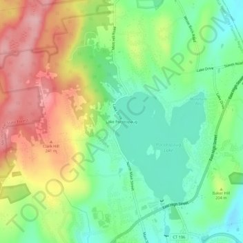
Nom : Carte topographique Lake Pocotopaug, altitude, relief.
Altitude moyenne : 184 m
Altitude minimum : 119 m
Altitude maximum : 275 m
Autres cartes topographiques
Cliquez sur une carte pour visualiser sa topographie, son altitude et son relief.
East Hampton
United States > Connecticut > Lower Connecticut River Valley Planning Region > East Hampton
East Hampton, Lower Connecticut River Valley Planning Region, Connecticut, 06424, United States
Altitude moyenne : 143 m
Pocotopaug Lake
United States > Connecticut > Lower Connecticut River Valley Planning Region > East Hampton > Lake Pocotopaug
Pocotopaug Lake, Lake Pocotopaug, East Hampton, Lower Connecticut River Valley Planning Region, Connecticut, United States
Altitude moyenne : 156 m