
Carte topographique Jerome
Carte interactive
Cliquez sur la carte pour afficher l’altitude.
À propos de cette carte
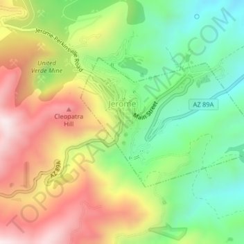
Nom : Carte topographique Jerome, altitude, relief.
Lieu : Jerome, Yavapai County, Arizona, 86331, United States (34.73958 -112.11939 34.75395 -112.09424)
Altitude moyenne : 1’574 m
Altitude minimum : 1’291 m
Altitude maximum : 1’930 m
Jerome is about 100 miles (160 km) north of Phoenix and 45 miles (72 km) southwest of Flagstaff along Arizona State Route 89A between Sedona to the east and Prescott to the west. The town is in Arizona's Black Hills, which trend north–south. The town lies within the Prescott National Forest at an elevation of more than 5,000 feet (1,500 m). Woodchute Wilderness is about 3 miles (5 km) west of Jerome, and Mingus Mountain, at 7,726 feet (2,355 m) above sea level, is about 4 miles (6 km) south of town. Jerome State Historic Park is in the town itself. Bitter Creek, a tributary of the Verde River, flows intermittently through Jerome. East of Jerome at the base of the hills are the Verde Valley and the communities of Clarkdale and Cottonwood, site of the nearest airport.
Autres cartes topographiques
Cliquez sur une carte pour visualiser sa topographie, son altitude et son relief.
Glen Oaks
United States > Arizona > Yavapai County
Glen Oaks, Yavapai County, Arizona, United States
Altitude moyenne : 1’717 m
Camp Verde
United States > Arizona > Yavapai County
Camp Verde, Yavapai County, Arizona, 86322, United States
Altitude moyenne : 1’095 m
Cordes
United States > Arizona > Yavapai County
Cordes, Yavapai County, Arizona, 86333, United States
Altitude moyenne : 1’170 m
Ocotillo
United States > Arizona > Yavapai County
Ocotillo, Yavapai County, Arizona, United States
Altitude moyenne : 1’302 m
Paulden
United States > Arizona > Yavapai County
Paulden, Yavapai County, Arizona, United States
Altitude moyenne : 1’408 m
Wagoner
United States > Arizona > Yavapai County > Wagoner
Wagoner, Yavapai County, Arizona, United States
Altitude moyenne : 1’063 m
Prescott Valley
United States > Arizona > Yavapai County
Prescott Valley, Yavapai County, Arizona, United States
Altitude moyenne : 1’550 m
Ash Fork
United States > Arizona > Yavapai County > Ash Fork
Ash Fork, Yavapai County, Arizona, 86320, United States
Altitude moyenne : 1’561 m
Dewey
United States > Arizona > Yavapai County > Prescott Valley > Dewey
Dewey, Prescott Valley, Yavapai County, Arizona, 86329, United States
Altitude moyenne : 1’415 m
Sedona
United States > Arizona > Yavapai County
Sedona, Yavapai County, Arizona, 86336, United States
Altitude moyenne : 1’342 m
Cleator
United States > Arizona > Yavapai County
Cleator, Yavapai County, Arizona, United States
Altitude moyenne : 1’083 m
Pica
United States > Arizona > Yavapai County
Pica, Yavapai County, Arizona, United States
Altitude moyenne : 1’613 m
Prescott
United States > Arizona > Yavapai County
Prescott, Yavapai County, Arizona, United States
Altitude moyenne : 1’674 m
Audley
United States > Arizona > Yavapai County
Audley, Yavapai County, Arizona, 96337, United States
Altitude moyenne : 1’591 m