
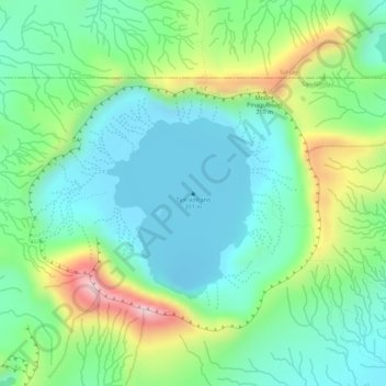
Carte topographique Taal Volcano
Carte interactive
Cliquez sur la carte pour afficher l’altitude.
À propos de cette carte
Nom : Carte topographique Taal Volcano, altitude, relief.
Altitude moyenne : 91 m
Altitude minimum : -6 m
Altitude maximum : 281 m
Volcano Island sank from 1 to 3 m (3 to 10 ft) as a result of the eruption. It was also found that the southern shore of Lake Taal sank in elevation from the eruption. No evidences of lava could be discovered anywhere, nor have geologists been able to trace any visible records of a lava flow having occurred at any time on the volcano back then. Another peculiarity of the geologic aspects of Taal is the fact that no sulphur has been found on the volcano. The yellow deposits and encrustations noticeable in the crater and its vicinity are iron salts, according to chemical analysis. A slight smell of sulfur was perceptible at the volcano, which came from the gases that escaped from the crater.
Autres cartes topographiques
Cliquez sur une carte pour visualiser sa topographie, son altitude et son relief.
Pulang-Bato
Philippines > Batangas > San Nicolas
Pulang-Bato, San Nicolas, Batangas, Calabarzon, 4207, Philippines
Altitude moyenne : 22 m
Taal Crater Lake
Philippines > Batangas > San Nicolas
Taal Crater Lake, San Nicolas, Batangas, Calabarzon, 4207, Philippines
Altitude moyenne : 90 m
Calangay
Philippines > Batangas > San Nicolas
Calangay, San Nicolas, Batangas, Calabarzon, 4211, Philippines
Altitude moyenne : 52 m
Pansipit River
Philippines > Batangas > San Nicolas > Talang
Pansipit River, Talang, San Nicolas, Batangas, Calabarzon, 4207, Philippines
Altitude moyenne : 39 m
San Nicolas
Philippines > Batangas > San Nicolas
San Nicolas, Batangas, Calabarzon, 4207, Philippines
Altitude moyenne : 68 m
Alas-as
Philippines > Batangas > San Nicolas > Alas-as
Alas-as, San Nicolas, Batangas, Calabarzon, Philippines
Altitude moyenne : 35 m
San Nicolas
Philippines > Batangas > San Nicolas
San Nicolas, Batangas, Calabarzon, 4207, Philippines
Altitude moyenne : 40 m