
Carte topographique Village of Hamilton
Carte interactive
Cliquez sur la carte pour afficher l’altitude.
À propos de cette carte
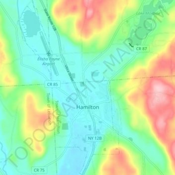
Nom : Carte topographique Village of Hamilton, altitude, relief.
Altitude moyenne : 386 m
Altitude minimum : 331 m
Altitude maximum : 502 m
The village, located at 42°49′32″N 75°32′40″W / 42.82556°N 75.54444°W / 42.82556; -75.54444 (42.825646, -75.544673), lies in the Chenango Valley, just south of the headwaters of the Chenango River. Northeast of the village is the river Payne Brook, which starts at Lake Moraine and travels through the village before converging with the Chenango River. The village is approximately 40 miles (64 km) southeast of Syracuse and 30 miles (48 km) southwest of Utica. The elevation of the village's municipal airport (Hamilton Municipal Airport) is approximately 1,100 feet (340 m) above sea level.
Autres cartes topographiques
Cliquez sur une carte pour visualiser sa topographie, son altitude et son relief.
Village of Earlville
United States > New York > Madison County > Town of Hamilton
Village of Earlville, Town of Hamilton, Madison County, New York, United States
Altitude moyenne : 342 m