
Carte topographique Spring Hill
Carte interactive
Cliquez sur la carte pour afficher l’altitude.
À propos de cette carte
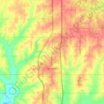
Nom : Carte topographique Spring Hill, altitude, relief.
Lieu : Spring Hill, Johnson County, Kansas, 66083, United States (38.71525 -94.85317 38.79665 -94.77897)
Altitude moyenne : 317 m
Altitude minimum : 279 m
Altitude maximum : 340 m
In 1856, James B. Hovey named the community after a town near Mobile, Alabama. "Being somewhat enthusiastic in my estimation of its future, it having all advantages of timber and water, and on a line that must be traveled between Olathe and Paola, I concluded to myself, as there was no one else to conclude with, that this was a good place for a town." – J.B. Hovey, 1857 Hovey served as the communities first postmaster. Also that year, Hovey built the first building in town, the Spring Hill Hotel. The two-story structure, also known as the "Old Traveler's Rest" was located on the highest elevation in town.
Autres cartes topographiques
Cliquez sur une carte pour visualiser sa topographie, son altitude et son relief.
Prairie Highlands
United States > Kansas > Johnson County > Olathe
Prairie Highlands, Olathe, Johnson County, Kansas, 66031, United States
Altitude moyenne : 314 m
Roeland Park
United States > Kansas > Johnson County
Roeland Park, Johnson County, Kansas, 66205, United States
Altitude moyenne : 291 m
Clearview City
United States > Kansas > Johnson County > De Soto
Clearview City, De Soto, Johnson County, Kansas, 66019, United States
Altitude moyenne : 273 m
Fairway
United States > Kansas > Johnson County
Fairway, Johnson County, Kansas, United States
Altitude moyenne : 290 m
Gardner
United States > Kansas > Johnson County
Gardner, Johnson County, Kansas, United States
Altitude moyenne : 317 m
Overland Park
United States > Kansas > Johnson County
Overland Park, Johnson County, Kansas, United States
Altitude moyenne : 300 m
Overland Park Arboretum and Botanical Gardens
United States > Kansas > Johnson County > Overland Park
Overland Park Arboretum and Botanical Gardens, Overland Park, Johnson County, Kansas, United States
Altitude moyenne : 305 m
Holliday
United States > Kansas > Johnson County > Shawnee
Holliday, Shawnee, Johnson County, Kansas, 66218, United States
Altitude moyenne : 252 m
Shawnee
United States > Kansas > Johnson County
Shawnee, Johnson County, Kansas, United States
Altitude moyenne : 285 m
Zarah
United States > Kansas > Johnson County > Shawnee
Zarah, Shawnee, Johnson County, Kansas, 66218, United States
Altitude moyenne : 268 m
Olathe
United States > Kansas > Johnson County
Olathe, Johnson County, Kansas, United States
Altitude moyenne : 309 m
Prairie Village
United States > Kansas > Johnson County
Prairie Village, Johnson County, Kansas, United States
Altitude moyenne : 300 m
Leawood
United States > Kansas > Johnson County
Leawood, Johnson County, Kansas, United States
Altitude moyenne : 289 m
Stilwell
United States > Kansas > Johnson County > Aubry
Stilwell, Aubry, Johnson County, Kansas, 66013, United States
Altitude moyenne : 326 m
Merriam
United States > Kansas > Johnson County
Merriam, Johnson County, Kansas, United States
Altitude moyenne : 306 m
De Soto
United States > Kansas > Johnson County
De Soto, Johnson County, Kansas, United States
Altitude moyenne : 276 m
Leawood
United States > Kansas > Johnson County
Leawood, Johnson County, Kansas, 64114, United States
Altitude moyenne : 286 m
Overland Park
United States > Kansas > Johnson County > Overland Park
Overland Park, Johnson County, Kansas, 66204, United States
Altitude moyenne : 288 m
Olathe
United States > Kansas > Johnson County > Olathe
Olathe, Johnson County, Kansas, 6601, United States
Altitude moyenne : 302 m
Elmhurst
United States > Kansas > Johnson County > Overland Park > Elmhurst
Elmhurst, Overland Park, Johnson County, Kansas, 66204, United States
Altitude moyenne : 313 m
Mission
United States > Kansas > Johnson County
Mission, Johnson County, Kansas, 66202, United States
Altitude moyenne : 301 m
Lenexa
United States > Kansas > Johnson County > Lenexa
Lenexa, Johnson County, Kansas, 66219, United States
Altitude moyenne : 290 m
Lake Quivira
United States > Kansas > Johnson County
Lake Quivira, Johnson County, Kansas, United States
Altitude moyenne : 269 m
Lenexa
United States > Kansas > Johnson County
Lenexa, Johnson County, Kansas, United States
Altitude moyenne : 301 m
Mission Hills
United States > Kansas > Johnson County
Mission Hills, Johnson County, Kansas, United States
Altitude moyenne : 288 m
Edgerton
United States > Kansas > Johnson County > Edgerton
Edgerton, Johnson County, Kansas, United States
Altitude moyenne : 308 m