
Carte topographique Münster
Carte interactive
Cliquez sur la carte pour afficher l’altitude.
À propos de cette carte
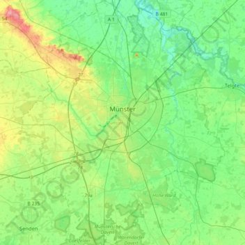
Nom : Carte topographique Münster, altitude, relief.
Lieu : Münster, North Rhine – Westphalia, Germany (51.84014 7.47379 52.06003 7.77436)
Altitude moyenne : 61 m
Altitude minimum : 37 m
Altitude maximum : 119 m
Münster is situated on the river Aa, approximately 15 kilometres (9 miles) south of its confluence with the Ems in the so-called Westphalian Bight, a landscape studded with dispersed settlements and farms – the "Münsterland". The Wolstonian sediments of the mountain ridge called "Münsterländer Kiessandzug" cross the city from north to south. The highest elevation is the Mühlenberg in the northwest of Münster, 97 metres above sea level. The lowest elevation is at the Ems, 44 m above sea level. The city centre is 60 m above sea level, measured at the Prinzipalmarkt in front of the historic city hall.
Autres cartes topographiques
Cliquez sur une carte pour visualiser sa topographie, son altitude et son relief.
Ginsburg
Germany > North Rhine – Westphalia > Kreis Siegen-Wittgenstein > Hilchenbach
Ginsburg, 1, Schloßberg, Hilchenbach, Kreis Siegen-Wittgenstein, North Rhine – Westphalia, 57271, Germany
Altitude moyenne : 510 m
Euskirchen
Germany > North Rhine – Westphalia > Kreis Euskirchen
Euskirchen, Kreis Euskirchen, North Rhine – Westphalia, Germany
Altitude moyenne : 230 m
Sindorf
Germany > North Rhine – Westphalia > Rhein-Erft-Kreis
Sindorf, Kerpen, Rhein-Erft-Kreis, North Rhine – Westphalia, 50170, Germany
Altitude moyenne : 85 m