
Carte topographique Kroměříž
Carte interactive
Cliquez sur la carte pour afficher l’altitude.
À propos de cette carte
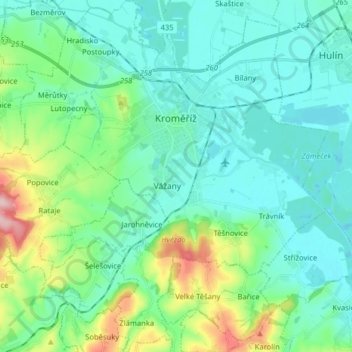
Nom : Carte topographique Kroměříž, altitude, relief.
Altitude moyenne : 220 m
Altitude minimum : 181 m
Altitude maximum : 368 m
Kroměříž is located about 20 kilometres (12 mi) northwest of Zlín. About two thirds of the municipal territory lies in the Litenčice Hills, eastern part lies in the Upper Morava Valley. A small southern part extends into the Chřiby mountain range. The highest point of the territory is the hill Obora with an elevation of 322 metres (1,056 ft). The town is situated on both banks of the Morava River.
Autres cartes topographiques
Cliquez sur une carte pour visualiser sa topographie, son altitude et son relief.
Sazovice
Czechia > Central Moravia > Zlínský kraj
Sazovice, okres Zlín, Zlínský kraj, Central Moravia, Czechia
Altitude moyenne : 235 m
Stupava
Czechia > Central Moravia > Zlínský kraj
Stupava, okres Uherské Hradiště, Zlínský kraj, Central Moravia, Czechia
Altitude moyenne : 428 m
Roštín
Czechia > Central Moravia > Zlínský kraj
Roštín, okres Kroměříž, Zlínský kraj, Central Moravia, 768 03, Czechia
Altitude moyenne : 353 m
Rožnov pod Radhoštěm
Czechia > Central Moravia > Zlínský kraj
Rožnov pod Radhoštěm, okres Vsetín, Zlínský kraj, Central Moravia, 756 61, Czechia
Altitude moyenne : 521 m