
Carte topographique Mount Arvon
Carte interactive
Cliquez sur la carte pour afficher l’altitude.
À propos de cette carte
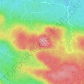
Nom : Carte topographique Mount Arvon, altitude, relief.
Altitude moyenne : 526 m
Altitude minimum : 455 m
Altitude maximum : 600 m
Mount Arvon, elevation 1,979 feet (603 m), is the highest natural point in the U.S. state of Michigan. Located in L'Anse Township, Baraga County, Mount Arvon is part of the Huron Mountains. It rises about eight miles (13 km) south of Lake Superior (elevation 591 feet [180 m]). On the list of highest natural points in each U.S. state, Mount Arvon ranks 38th. It is the highest natural point in the East North Central states.
Autres cartes topographiques
Cliquez sur une carte pour visualiser sa topographie, son altitude et son relief.
L'Anse Township
United States > Michigan > Baraga County
L'Anse Township, Baraga County, Michigan, 49946, United States
Altitude moyenne : 388 m
Aura
United States > Michigan > Baraga County > Aura
Aura, L'Anse Township, Baraga County, Michigan, United States
Altitude moyenne : 240 m
L'Anse
United States > Michigan > Baraga County > L'Anse
L'Anse, L'Anse Township, Baraga County, Michigan, 49946, United States
Altitude moyenne : 224 m
Ruth Lake
United States > Michigan > Baraga County > Three Lakes
Ruth Lake, Three Lakes, Spurr Township, Baraga County, Michigan, United States
Altitude moyenne : 507 m