
Carte topographique Sumner Lake State Park
Carte interactive
Cliquez sur la carte pour afficher l’altitude.
À propos de cette carte
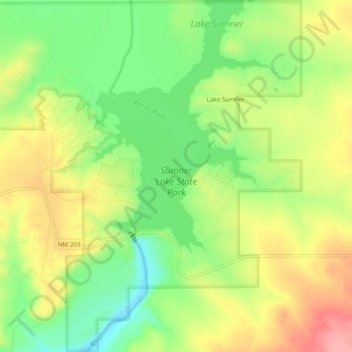
Nom : Carte topographique Sumner Lake State Park, altitude, relief.
Altitude moyenne : 1’311 m
Altitude minimum : 1’262 m
Altitude maximum : 1’364 m
The park features a large 4,500-acre (18 km2) reservoir on the Pecos River, created in 1939 by the Sumner Dam of the United States Bureau of Reclamation. The reservoir is home to various fish species including largemouth bass, catfish, crappie and walleye. The park elevation is 4,300 feet (1,300 m) above sea level. With its campground, expansive views of the sky, and its distance from other cities, Sumner Lake State Park has a low level of light pollution, which makes the state park a great potential place for amateur astronomy.
Autres cartes topographiques
Cliquez sur une carte pour visualiser sa topographie, son altitude et son relief.
White Mesa
United States > New Mexico > De Baca County
White Mesa, De Baca County, New Mexico, United States
Altitude moyenne : 1’348 m