
Carte topographique Bandelier National Monument
Carte interactive
Cliquez sur la carte pour afficher l’altitude.
À propos de cette carte
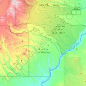
Nom : Carte topographique Bandelier National Monument, altitude, relief.
Altitude moyenne : 2’130 m
Altitude minimum : 1’630 m
Altitude maximum : 3’185 m
The monument is 50 square miles (130 km2) of the Pajarito Plateau, on the slopes of the Jemez volcanic field in the Jemez Mountains. Over 70% of the monument is wilderness, with over one mile of elevation change, from about 5,000 feet (1,500 m) along the Rio Grande to over 10,000 feet (3,000 m) at the peak of Cerro Grande on the rim of the Valles Caldera, providing for a wide range of life zones and wildlife habitats. 3 miles (5 km) of road and more than 70 miles (110 km) of hiking trails are built. The monument protects Ancestral Pueblo archeological sites, a diverse and scenic landscape, and the country's largest National Park Service Civilian Conservation Corps National Landmark District. Two-thirds of the park, 23,267 acres (9,416 ha), is designated as the Bandelier Wilderness Area. Motorized travel and permanent structures are forbidden in the Wilderness.
Autres cartes topographiques
Cliquez sur une carte pour visualiser sa topographie, son altitude et son relief.
Rio Rancho
United States > New Mexico > Sandoval County
Rio Rancho, Sandoval County, New Mexico, United States
Altitude moyenne : 1’672 m
Santa Ana Pueblo
United States > New Mexico > Sandoval County
Santa Ana Pueblo, Sandoval County, New Mexico, 87004, United States
Altitude moyenne : 1’558 m
Placitas
United States > New Mexico > Sandoval County
Placitas, Sandoval County, New Mexico, 87043, United States
Altitude moyenne : 1’864 m
Santo Domingo Pueblo / Kewa
United States > New Mexico > Sandoval County
Santo Domingo Pueblo / Kewa, Sandoval County, New Mexico, United States
Altitude moyenne : 1’589 m
Cochiti
United States > New Mexico > Sandoval County
Cochiti, Sandoval County, New Mexico, United States
Altitude moyenne : 1’607 m
Rio Rancho
United States > New Mexico > Sandoval County > Rio Rancho
Rio Rancho, Sandoval County, New Mexico, 87144, United States
Altitude moyenne : 1’733 m
The Monarch
United States > New Mexico > Sandoval County > Rio Rancho
The Monarch, Rio Rancho, Sandoval County, New Mexico, United States
Altitude moyenne : 1’731 m
Kasha-Katuwe Tent Rocks National Monument
United States > New Mexico > Sandoval County
Kasha-Katuwe Tent Rocks National Monument, Sandoval County, New Mexico, United States
Altitude moyenne : 1’852 m
Pajarito Mountain
United States > New Mexico > Sandoval County
Pajarito Mountain, Sandoval County, New Mexico, United States
Altitude moyenne : 2’936 m
Zia Pueblo
United States > New Mexico > Sandoval County > Zia Pueblo
Zia Pueblo, Sandoval County, New Mexico, United States
Altitude moyenne : 1’707 m
Corrales
United States > New Mexico > Sandoval County
Corrales, Sandoval County, New Mexico, 87048, United States
Altitude moyenne : 1’557 m
Valles Caldera
United States > New Mexico > Sandoval County
Valles Caldera, Sandoval County, New Mexico, United States
Altitude moyenne : 2’772 m
Cochiti Lake
United States > New Mexico > Sandoval County
Cochiti Lake, Sandoval County, New Mexico, 87083, United States
Altitude moyenne : 1’683 m
Torreon
United States > New Mexico > Sandoval County
Torreon, Eastern Navajo Agency, Sandoval County, New Mexico, United States
Altitude moyenne : 1’984 m
San Felipe Pueblo
United States > New Mexico > Sandoval County > San Felipe Pueblo
San Felipe Pueblo, Sandoval County, New Mexico, United States
Altitude moyenne : 1’640 m
Corrales
United States > New Mexico > Sandoval County > Corrales
Corrales, Sandoval County, New Mexico, 87048, United States
Altitude moyenne : 1’534 m
Jemez Springs
United States > New Mexico > Sandoval County
Jemez Springs, Sandoval County, New Mexico, 87924, United States
Altitude moyenne : 2’142 m
Cuba
United States > New Mexico > Sandoval County > Cuba
Cuba, Sandoval County, New Mexico, United States
Altitude moyenne : 2’112 m