
Carte topographique Laramie
Carte interactive
Cliquez sur la carte pour afficher l’altitude.
À propos de cette carte
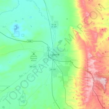
Nom : Carte topographique Laramie, altitude, relief.
Lieu : Laramie, Albany County, Wyoming, 82070, United States (41.15137 -105.75110 41.47137 -105.43110)
Altitude moyenne : 2’299 m
Altitude minimum : 2’133 m
Altitude maximum : 2’744 m
Laramie is on a high plain between two mountain ranges, the Snowy Range, about 30 miles (48 km) to the west, and the Laramie Range, 7 miles (11 km) to the east. The city's elevation above sea level is approximately 7,165 feet (2,184 m). The Laramie River runs through Laramie toward its confluence with the North Platte River east of the Laramie Range.