
Carte topographique Hayes County
Carte interactive
Cliquez sur la carte pour afficher l’altitude.
À propos de cette carte
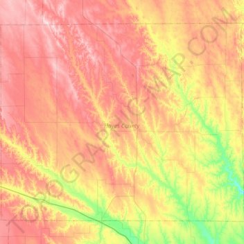
Nom : Carte topographique Hayes County, altitude, relief.
Lieu : Hayes County, Nebraska, 69032, United States of America (40.34876 -101.34319 40.70016 -100.77559)
Altitude moyenne : 921 m
Altitude minimum : 796 m
Altitude maximum : 1’038 m
The terrain of Hayes County is hilly. The flattened hilltops are largely used for center pivot irrigation. Small creeks and streams drain the upper elevations; the largest is Red Willow Creek, which drains to Hugh Butler Lake just east of the SE corner of Hayes County, in Frontier County. The county has a total area of 713 square miles (1,850 km2), of which 713 square miles (1,850 km2) is land and 0.2 square miles (0.52 km2) (0.03%) is water.
Autres cartes topographiques
Cliquez sur une carte pour visualiser sa topographie, son altitude et son relief.
Chadron
United States of America > Nebraska > Chadron
Chadron, Dawes County, Nebraska, 69337, United States of America
Altitude moyenne : 1’052 m
Red Cloud
United States of America > Nebraska > Red Cloud
Red Cloud, Webster County, Nebraska, United States of America
Altitude moyenne : 525 m
Osceola
United States of America > Nebraska > Osceola
Osceola, Polk County, Nebraska, 68651, United States of America
Altitude moyenne : 507 m
Maywood
United States of America > Nebraska > Maywood
Maywood, Frontier County, Nebraska, United States of America
Altitude moyenne : 829 m
Craig
United States of America > Nebraska > Craig
Craig, Burt County, Nebraska, United States of America
Altitude moyenne : 398 m
Webster County
United States of America > Nebraska
Webster County, Nebraska, United States of America
Altitude moyenne : 576 m
Staplehurst
United States of America > Nebraska > Staplehurst
Staplehurst, Seward County, Nebraska, United States of America
Altitude moyenne : 456 m
Malcolm
United States of America > Nebraska > Malcolm
Malcolm, Lancaster County, Nebraska, United States of America
Altitude moyenne : 406 m