Géolocaliser

Carte topographique Brooksville

Carte interactive

Cliquez sur la carte pour afficher l’altitude.

À propos de cette carte

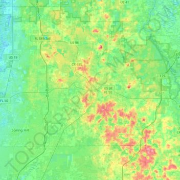
Nom : Carte topographique Brooksville, altitude, relief.

Lieu : Brooksville, Hernando County, Florida, United States (28.48943 -82.47828 28.58760 -82.09635)

Altitude moyenne : 29 m

Altitude minimum : 2 m

Altitude maximum : 93 m

Brooksville is known for its rolling topography with elevations ranging from 100 ft to 180 ft. The highest elevation in the area is Chinsegut Hill, at 269 ft, over five and a half miles north of the city.

Wikipedia (CC-BY-SA 3.0)

Autres cartes topographiques

Cliquez sur une carte pour visualiser sa topographie, son altitude et son relief.

Nobleton

United States > Florida > Hernando County > Nobleton

Nobleton, Hernando County, Florida, 34661, United States

Altitude moyenne : 21 m

Weeki Wachee

United States > Florida > Hernando County

Weeki Wachee, Hernando County, Florida, United States

Altitude moyenne : 11 m

Hernando Beach

United States > Florida > Hernando County

Hernando Beach, Hernando County, Florida, United States

Altitude moyenne : 3 m

Weeki Wachee Gardens

United States > Florida > Hernando County

Weeki Wachee Gardens, Hernando County, Florida, United States

Altitude moyenne : 4 m

South Brooksville

United States > Florida > Hernando County

South Brooksville, Hernando County, Florida, United States

Altitude moyenne : 41 m

Pine Island

United States > Florida > Hernando County > Pine Island

Pine Island, Hernando County, Florida, United States

Altitude moyenne : 1 m

Spring Hill

United States > Florida > Hernando County

Spring Hill, Hernando County, Florida, United States

Altitude moyenne : 18 m

Weeki Wachee Spring

United States > Florida > Hernando County > Spring Hill > Weeki Wachee

Weeki Wachee Spring, Commercial Way, Weeki Wachee, Spring Hill, Hernando County, Florida, 34606, United States

Altitude moyenne : 11 m

Ridge Manor

United States > Florida > Hernando County > Ridge Manor

Ridge Manor, Brooksville, Hernando County, Florida, United States

Altitude moyenne : 22 m

Timber Pines

United States > Florida > Hernando County > Timber Pines

Timber Pines, Hernando County, Florida, United States

Altitude moyenne : 12 m

Weeki Wachee Acres

United States > Florida > Hernando County > Weeki Wachee Acres

Weeki Wachee Acres, Hernando County, Florida, 34606, United States

Altitude moyenne : 11 m

Hill 'n Dale

United States > Florida > Hernando County > Hill 'n Dale

Hill 'n Dale, Hernando County, Florida, 34602, United States

Altitude moyenne : 30 m

Richloam

United States > Florida > Hernando County > Richloam

Richloam, Hernando County, Florida, United States

Altitude moyenne : 25 m

Beacon Rock

United States > Florida > Hernando County

Beacon Rock, Hernando County, Florida, United States

Altitude moyenne : 9 m