
Carte topographique Climie
Carte interactive
Cliquez sur la carte pour afficher l’altitude.
À propos de cette carte
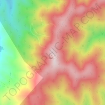
Nom : Carte topographique Climie, altitude, relief.
Altitude moyenne : 609 m
Altitude minimum : 265 m
Altitude maximum : 856 m
Autres cartes topographiques
Cliquez sur une carte pour visualiser sa topographie, son altitude et son relief.
Mangaroa River
New Zealand > Wellington > Upper Hutt
Mangaroa River, Upper Hutt, Upper Hutt City, Wellington, 5371, New Zealand
Altitude moyenne : 283 m
Te Haukaretu Park
New Zealand > Wellington > Upper Hutt
Te Haukaretu Park, Maoribank, Upper Hutt, Upper Hutt City, Wellington, New Zealand
Altitude moyenne : 113 m
Okupe Lagoon
New Zealand > Wellington > Upper Hutt
Okupe Lagoon, Boulder Bank Loop, Upper Hutt, Wellington, New Zealand
Altitude moyenne : 26 m
Akatarawa River
New Zealand > Wellington > Upper Hutt
Akatarawa River, Upper Hutt, Upper Hutt City, Wellington, 6007, New Zealand
Altitude moyenne : 428 m
Whakatikei River
New Zealand > Wellington > Upper Hutt
Whakatikei River, Upper Hutt, Upper Hutt City, Wellington, 5018, New Zealand
Altitude moyenne : 316 m
Pakuratahi River
New Zealand > Wellington > Upper Hutt
Pakuratahi River, Upper Hutt, Upper Hutt City, Wellington, New Zealand
Altitude moyenne : 353 m