
Carte topographique Vertainspitze - Cima Vertana
Carte interactive
Cliquez sur la carte pour afficher l’altitude.
À propos de cette carte
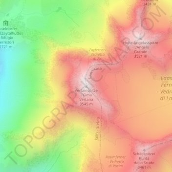
Nom : Carte topographique Vertainspitze - Cima Vertana, altitude, relief.
Altitude moyenne : 3’055 m
Altitude minimum : 2’454 m
Altitude maximum : 3’527 m
Autres cartes topographiques
Cliquez sur une carte pour visualiser sa topographie, son altitude et son relief.
Untere Tartscher Alm
Italië > Trento-Zuid-Tirol > Stilfs - Stelvio > Untere Tartscher Alm
Untere Tartscher Alm, Stilfs - Stelvio, Vinschgau - Val Venosta, Bolzano - Bozen, Trento-Zuid-Tirol, Italië
Altitude moyenne : 2’128 m