
Carte topographique Village of Cambridge
Carte interactive
Cliquez sur la carte pour afficher l’altitude.
À propos de cette carte
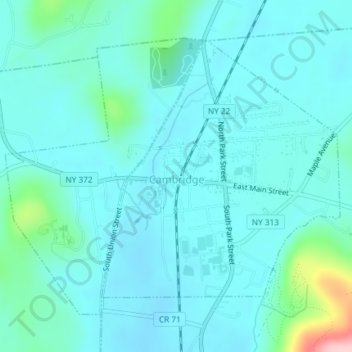
Nom : Carte topographique Village of Cambridge, altitude, relief.
Altitude moyenne : 165 m
Altitude minimum : 138 m
Altitude maximum : 326 m
Autres cartes topographiques
Cliquez sur une carte pour visualiser sa topographie, son altitude et son relief.
Bald Mountain
United States > New York > Washington County
Bald Mountain, Washington County, New York, United States
Altitude moyenne : 261 m
Town of Dresden
United States > New York > Washington County
Town of Dresden, Washington County, New York, United States
Altitude moyenne : 249 m
Black Mountain
United States > New York > Washington County
Black Mountain, Town of Dresden, Washington County, New York, 12841, United States
Altitude moyenne : 487 m
West Hebron
United States > New York > Washington County > West Hebron
West Hebron, Town of Hebron, Washington County, New York, 12865, United States
Altitude moyenne : 209 m
Putnam Station
United States > New York > Washington County > Putnam Station
Putnam Station, Town of Putnam, Washington County, New York, United States
Altitude moyenne : 83 m
West Cambridge
United States > New York > Washington County > Town of Cambridge
West Cambridge, Town of Cambridge, Washington County, New York, United States
Altitude moyenne : 199 m
Village of Fort Edward
United States > New York > Washington County
Village of Fort Edward, Town of Fort Edward, Washington County, New York, United States
Altitude moyenne : 52 m