
Carte topographique Colby
Carte interactive
Cliquez sur la carte pour afficher l’altitude.
À propos de cette carte
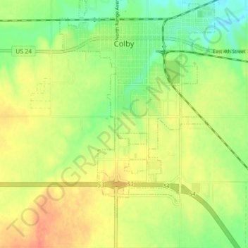
Nom : Carte topographique Colby, altitude, relief.
Lieu : Colby, Thomas County, Kansas, 67701, United States (39.35076 -101.07105 39.40552 -101.00097)
Altitude moyenne : 970 m
Altitude minimum : 946 m
Altitude maximum : 992 m
Colby is located at 39°23′32″N 101°02′51″W / 39.392093°N 101.047532°W / 39.392093; -101.047532 (39.392093, -101.047532) at an elevation of 3,159 feet (963 m). It lies on the south side of Prairie Dog Creek, a tributary of the Republican River, in the High Plains region of the Great Plains. A small tributary of the creek flows northeast through the town. Located at the interchange of Interstate 70 and K-25 in northwestern Kansas, Colby is 212 mi (341 km) east-southeast of Denver, 232 mi (373 km) northwest of Wichita, and 347 mi (558 km) west of Kansas City.
Autres cartes topographiques
Cliquez sur une carte pour visualiser sa topographie, son altitude et son relief.
Great Plains
United States > Kansas > Thomas County
Great Plains, Thomas County, Kansas, United States
Altitude moyenne : 1’023 m
Brewster
United States > Kansas > Thomas County
Brewster, Thomas County, Kansas, United States
Altitude moyenne : 1’040 m