
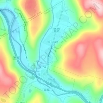
Carte topographique Roscoe
Carte interactive
Cliquez sur la carte pour afficher l’altitude.
À propos de cette carte
Nom : Carte topographique Roscoe, altitude, relief.
Altitude moyenne : 487 m
Altitude minimum : 374 m
Altitude maximum : 665 m
Autres cartes topographiques
Cliquez sur une carte pour visualiser sa topographie, son altitude et son relief.
Debruce
United States > New York > Sullivan County > Town of Rockland
Debruce, Town of Rockland, Sullivan County, New York, 12768, United States
Altitude moyenne : 600 m
Deckertown
United States > New York > Sullivan County > Town of Rockland
Deckertown, Town of Rockland, Sullivan County, New York, 12758, United States
Altitude moyenne : 531 m
Anderson
United States > New York > Sullivan County > Town of Rockland
Anderson, Town of Rockland, Sullivan County, New York, 12768, United States
Altitude moyenne : 612 m
Livingston Manor
United States > New York > Sullivan County > Town of Rockland
Livingston Manor, Town of Rockland, Sullivan County, New York, 12758, United States
Altitude moyenne : 515 m
Parkston
United States > New York > Sullivan County > Town of Rockland > Parkston
Parkston, Town of Rockland, Sullivan County, New York, 12758, United States
Altitude moyenne : 567 m