
Carte topographique High Littleton
Cliquez sur la carte pour afficher l’altitude.
À propos de cette carte
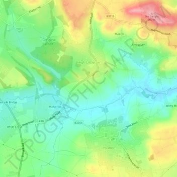
Nom : Carte topographique High Littleton, altitude, relief.
Altitude moyenne : 122 m
Altitude minimum : 74 m
Altitude maximum : 201 m
Autres cartes topographiques
Cliquez sur une carte pour visualiser sa topographie, son altitude et son relief.
Bathwick Hill
United Kingdom > England > Bath and North East Somerset > Bath
Number 1 (Bathwick Lodge) is a 2-storey villa with a steep Mansard room, built in 1825, extended in 1840 and the late C19. Probably by John Pinch the Elder.[4] Number 2 is from the early 19th century and has shutters over the windows.[11] Number 3 includes a porch which is elaborately enriched with carving,…
Altitude moyenne : 93 m
Hallatrow
United Kingdom > England > Bath and North East Somerset > High Littleton
Altitude moyenne : 119 m
Norton Hawkfield
United Kingdom > England > Bath and North East Somerset > Norton Malreward
Altitude moyenne : 96 m
Knowle Hill
United Kingdom > England > Bath and North East Somerset > Chew Magna
Altitude moyenne : 65 m
Little Solsbury Hill
United Kingdom > England > Bath and North East Somerset > Batheaston
Altitude moyenne : 88 m
Monger
United Kingdom > England > Bath and North East Somerset > Midsomer Norton
Altitude moyenne : 118 m
Park Corner
United Kingdom > England > Bath and North East Somerset > Freshford > Park Corner
Altitude moyenne : 93 m
Sharpstone
United Kingdom > England > Bath and North East Somerset > Freshford
Altitude moyenne : 93 m
Chewton Keynsham
United Kingdom > England > Bath and North East Somerset > Compton Dando
Altitude moyenne : 57 m
North Wick
United Kingdom > England > Bath and North East Somerset > Chew Magna
Altitude moyenne : 110 m
Carlingcott
United Kingdom > England > Bath and North East Somerset > Peasedown St. John
Altitude moyenne : 123 m
Pipehouse
United Kingdom > England > Bath and North East Somerset > Hinton Charterhouse
Altitude moyenne : 94 m
Keynsham Memorial Park
United Kingdom > England > Bath and North East Somerset > Keynsham
Altitude moyenne : 29 m
Stoney Littleton
United Kingdom > England > Bath and North East Somerset > Shoscombe
Altitude moyenne : 116 m
Clutton Hill
United Kingdom > England > Bath and North East Somerset > Farmborough
Altitude moyenne : 133 m
Maes Knoll
United Kingdom > England > Bath and North East Somerset > Norton Malreward
Altitude moyenne : 110 m
Wick Green
United Kingdom > England > Bath and North East Somerset > Bishop Sutton
Altitude moyenne : 82 m
Whitley Batts
United Kingdom > England > Bath and North East Somerset > Pensford
Altitude moyenne : 87 m
Monger
United Kingdom > England > Bath and North East Somerset > Midsomer Norton
Altitude moyenne : 118 m