
Carte topographique Brasstown Bald
Carte interactive
Cliquez sur la carte pour afficher l’altitude.
À propos de cette carte
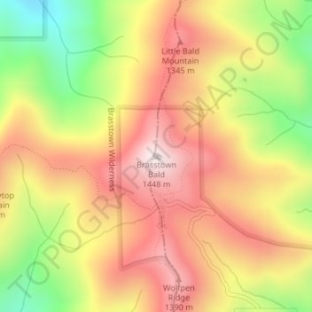
Nom : Carte topographique Brasstown Bald, altitude, relief.
Lieu : Brasstown Bald, Towns County, Georgia, United States (34.87431 -83.81110 34.87441 -83.81100)
Altitude moyenne : 1’161 m
Altitude minimum : 798 m
Altitude maximum : 1’442 m
Autres cartes topographiques
Cliquez sur une carte pour visualiser sa topographie, son altitude et son relief.
Presley
United States > Georgia > Towns County
Presley, Towns County, Georgia, 30546, United States
Altitude moyenne : 653 m
Hiawassee
United States > Georgia > Towns County
Hiawassee, Towns County, Georgia, United States
Altitude moyenne : 620 m
Young Harris
United States > Georgia > Towns County
Young Harris, Towns County, Georgia, United States
Altitude moyenne : 606 m