
Carte topographique Buchegg
Carte interactive
Cliquez sur la carte pour afficher l’altitude.
À propos de cette carte
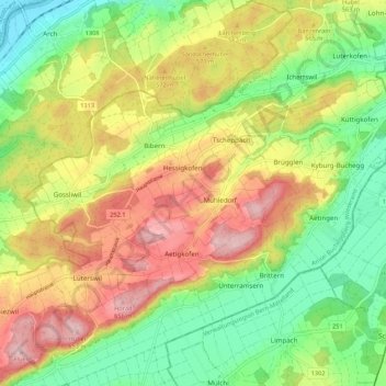
Nom : Carte topographique Buchegg, altitude, relief.
Altitude moyenne : 534 m
Altitude minimum : 427 m
Altitude maximum : 666 m
Autres cartes topographiques
Cliquez sur une carte pour visualiser sa topographie, son altitude et son relief.
Lohn-Ammannsegg
Schweiz > Solothurn > Amtei Bucheggberg-Wasseramt
Lohn-Ammannsegg, Bezirk Wasseramt, Amtei Bucheggberg-Wasseramt, Solothurn, 4573, Schweiz
Altitude moyenne : 507 m
Lüsslingen-Nennigkofen
Schweiz > Solothurn > Amtei Bucheggberg-Wasseramt
Lüsslingen-Nennigkofen, Bezirk Bucheggberg, Amtei Bucheggberg-Wasseramt, Solothurn, 4574, Schweiz
Altitude moyenne : 471 m
Recherswil
Schweiz > Solothurn > Amtei Bucheggberg-Wasseramt
Recherswil, Bezirk Wasseramt, Amtei Bucheggberg-Wasseramt, Solothurn, 4565, Schweiz
Altitude moyenne : 463 m