
Carte topographique Klüt
Carte interactive
Cliquez sur la carte pour afficher l’altitude.
À propos de cette carte
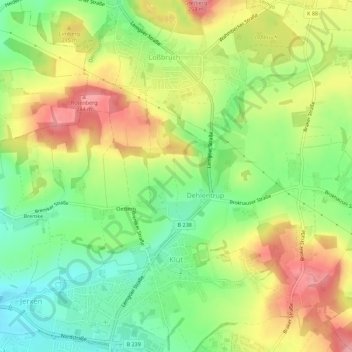
Nom : Carte topographique Klüt, altitude, relief.
Lieu : Klüt, Detmold, Kreis Lippe, Nordrhein-Westfalen, Deutschland (51.95315 8.88262 51.98763 8.93253)
Altitude moyenne : 187 m
Altitude minimum : 131 m
Altitude maximum : 252 m
Autres cartes topographiques
Cliquez sur une carte pour visualiser sa topographie, son altitude et son relief.
Schling
Deutschland > Nordrhein-Westfalen > Kreis Lippe > Detmold
Schling, Detmold, Kreis Lippe, Nordrhein-Westfalen, 32760, Deutschland
Altitude moyenne : 255 m
Berlebeck
Deutschland > Nordrhein-Westfalen > Kreis Lippe > Detmold
Berlebeck, Detmold, Kreis Lippe, Nordrhein-Westfalen, Deutschland
Altitude moyenne : 296 m