
Faire un don
Équipez-vous pour votre prochaine aventure :
En tant que Partenaire Amazon, ce site perçoit une commission sur les achats éligibles sans surcoût pour vous.
Carte topographique Greymouth
Cliquez sur la carte pour afficher l’altitude.
Faire un don
Équipez-vous pour votre prochaine aventure :
En tant que Partenaire Amazon, ce site perçoit une commission sur les achats éligibles sans surcoût pour vous.
Greymouth
A combination of high intensity rainfall, high topographic relief and short steep rivers often leads to rapid flooding of low-lying land across the West Coast. Since its founding Greymouth has experienced two dozen floods by the Grey River, with many of the most significant being assigned names: for example, the Great Flood (1872), the Jubilee Flood (1887), the Big Flood (1905), The Biggest Since 1887 (1936), The Biggest Since 1936 (1977), The Big One (May 1988) and The Biggest (September 1988). After the two floods in 1988 the mayor of Greymouth, Barry Dallas, organised the construction of a flood protection wall. Rising 2 m above the level of the railway embankment and riverside wharf, it was completed in September 1990 at a cost of NZ$4m. Since its completion Greymouth has not suffered a significant flood, although the river has come close to the top of the flood wall several times.
Faire un don
Équipez-vous pour votre prochaine aventure :
En tant que Partenaire Amazon, ce site perçoit une commission sur les achats éligibles sans surcoût pour vous.
À propos de cette carte
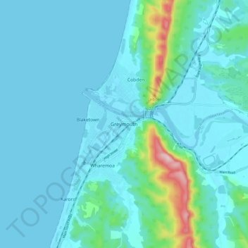
Nom : Carte topographique Greymouth, altitude, relief.
Lieu : Greymouth, Grey District, West Coast, 7801, New Zealand (-42.48995 171.16799 -42.40995 171.24799)
Altitude moyenne : 40 m
Altitude minimum : -3 m
Altitude maximum : 337 m
Faire un don
Équipez-vous pour votre prochaine aventure :
En tant que Partenaire Amazon, ce site perçoit une commission sur les achats éligibles sans surcoût pour vous.