
Carte topographique Lake Tekapo
Carte interactive
Cliquez sur la carte pour afficher l’altitude.
À propos de cette carte
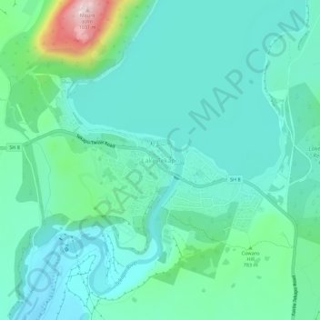
Nom : Carte topographique Lake Tekapo, altitude, relief.
Lieu : Lake Tekapo, Mackenzie District, Canterbury, New Zealand (-44.02371 170.45848 -43.98371 170.49848)
Altitude moyenne : 744 m
Altitude minimum : 673 m
Altitude maximum : 1’030 m
Autres cartes topographiques
Cliquez sur une carte pour visualiser sa topographie, son altitude et son relief.
Phantom Lagoon
New Zealand > Canterbury > Lake Tekapo
Phantom Lagoon, Lilybank Road, Lake Tekapo, Mackenzie District, Canterbury, New Zealand
Altitude moyenne : 1’155 m
Roys Lagoon
New Zealand > Canterbury > Lake Tekapo
Roys Lagoon, Lilybank Road, Lake Tekapo, Mackenzie District, Canterbury, New Zealand
Altitude moyenne : 801 m
Trig 'N' Tarn
New Zealand > Canterbury > Lake Tekapo
Trig 'N' Tarn, Godley Peaks Road, Lake Tekapo, Mackenzie District, Canterbury, New Zealand
Altitude moyenne : 757 m