
Carte topographique Damascus
Carte interactive
Cliquez sur la carte pour afficher l’altitude.
À propos de cette carte
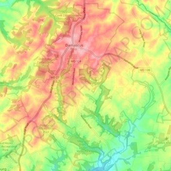
Nom : Carte topographique Damascus, altitude, relief.
Lieu : Damascus, Montgomery County, Maryland, 20872, United States (39.22923 -77.23627 39.30973 -77.15600)
Altitude moyenne : 195 m
Altitude minimum : 122 m
Altitude maximum : 260 m
As an unincorporated area, Damascus' boundaries are not officially defined. Damascus is recognized by the United States Census Bureau as a census-designated place, and by the United States Geological Survey as a populated place located at 39°16′16″N 77°12′22″W / 39.27111°N 77.20611°W / 39.27111; -77.20611 (39.271040, −77.206098). Damascus proper is a locally high spot at 847 ft (258m) above sea level, while other portions of the area described as Damascus are as high as 866 ft (264m) above sea level. However the highest elevation in the county is actually within what is considered Mt. Airy, MD, measuring 883 ft (269m) above sea level at the Full Gospel Church. This peak just southwest of Mt. Airy is actually the highest elevation in the immediately adjacent Washington D.C. suburbs.