
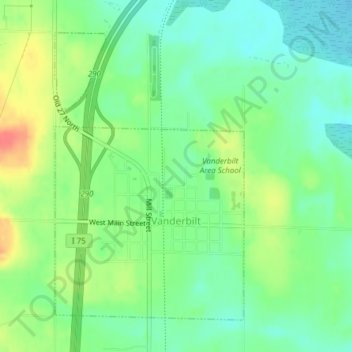
Carte topographique Vanderbilt
Carte interactive
Cliquez sur la carte pour afficher l’altitude.
À propos de cette carte
Nom : Carte topographique Vanderbilt, altitude, relief.
Altitude moyenne : 334 m
Altitude minimum : 313 m
Altitude maximum : 369 m
Autres cartes topographiques
Cliquez sur une carte pour visualiser sa topographie, son altitude et son relief.
Gaylord
United States > Michigan > Otsego County
Gaylord, Otsego County, Michigan, United States
Altitude moyenne : 401 m
Elmira
United States > Michigan > Otsego County
Elmira, Elmira Township, Otsego County, Michigan, 49730, United States
Altitude moyenne : 389 m
Knowlton Lake
United States > Michigan > Otsego County
Knowlton Lake, Bagley Township, Otsego County, Michigan, United States
Altitude moyenne : 399 m
Hayes Township
United States > Michigan > Otsego County
Hayes Township, Otsego County, Michigan, United States
Altitude moyenne : 407 m
Lake Marjory
United States > Michigan > Otsego County
Lake Marjory, Otsego Lake Township, Otsego County, Michigan, United States
Altitude moyenne : 404 m