
Faire un don
Équipez-vous pour votre prochaine aventure :
En tant que Partenaire Amazon, ce site perçoit une commission sur les achats éligibles sans surcoût pour vous.
Carte topographique Allrode
Cliquez sur la carte pour afficher l’altitude.
Faire un don
Équipez-vous pour votre prochaine aventure :
En tant que Partenaire Amazon, ce site perçoit une commission sur les achats éligibles sans surcoût pour vous.
À propos de cette carte
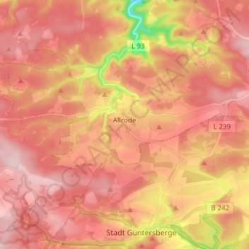
Nom : Carte topographique Allrode, altitude, relief.
Lieu : Allrode, Thale, Landkreis Harz, Sachsen-Anhalt, Deutschland (51.65308 10.89596 51.69955 11.01930)
Altitude moyenne : 462 m
Altitude minimum : 289 m
Altitude maximum : 547 m
Faire un don
Équipez-vous pour votre prochaine aventure :
En tant que Partenaire Amazon, ce site perçoit une commission sur les achats éligibles sans surcoût pour vous.
Autres cartes topographiques
Cliquez sur une carte pour visualiser sa topographie, son altitude et son relief.
Hexentanzplatz
Deutschland > Sachsen-Anhalt > Landkreis Harz > Thale
Über den Hexentanzplatz ziehen sich Reste des Sachsenwalles. Dabei handelt es sich um eine 150 m lange Trockenmauer aus Granitsteinen von einst 2 m Höhe. Sie wurde etwa 750 bis 450 v. Chr. errichtet. Die Mauer schirmte Teile des erhöhten Geländes des Hexentanzplatzes ab und diente vermutlich als Fliehburg.
Altitude moyenne : 379 m
Bodetal
Deutschland > Sachsen-Anhalt > Landkreis Harz > Thale
Ein zehn Kilometer langer Wanderweg erschließt die Bodeschlucht zwischen Thale und Treseburg. An Engstellen wird der Weg in steilen Kehren und als Fußpfad über Felsen geführt. Von dort ergeben sich hervorragende Ausblicke in die Schlucht. Zuwegungen ins Tal gehen von den Aussichtsfelsen an Roßtrappe und…
Altitude moyenne : 390 m
Hexentanzplatz
Deutschland > Sachsen-Anhalt > Landkreis Harz > Thale
Über den Hexentanzplatz ziehen sich Reste des Sachsenwalles. Dabei handelt es sich um eine 150 m lange Trockenmauer aus Granitsteinen von einst 2 m Höhe. Sie wurde etwa 750 bis 450 v. Chr. errichtet. Die Mauer schirmte Teile des erhöhten Geländes des Hexentanzplatzes ab und diente vermutlich als Fliehburg.
Altitude moyenne : 397 m
Faire un don
Équipez-vous pour votre prochaine aventure :
En tant que Partenaire Amazon, ce site perçoit une commission sur les achats éligibles sans surcoût pour vous.