
Carte topographique West Midlands
Carte interactive
Cliquez sur la carte pour afficher l’altitude.
À propos de cette carte
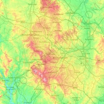
Nom : Carte topographique West Midlands, altitude, relief.
Altitude moyenne : 113 m
Altitude minimum : 15 m
Altitude maximum : 307 m
Autres cartes topographiques
Cliquez sur une carte pour visualiser sa topographie, son altitude et son relief.
Nuneaton and Bedworth
United Kingdom > England > Warwickshire
Nuneaton and Bedworth, Warwickshire, England, United Kingdom
Altitude moyenne : 108 m
Warwick Castle
United Kingdom > England > Warwickshire > Warwick
Warwick Castle, Northern Tower, Cliff Hill, Warwick, Warwickshire, England, CV34 4QX, United Kingdom
Altitude moyenne : 56 m
Sherbourne
United Kingdom > England > Warwickshire > Warwick
Sherbourne, Warwick, Warwickshire, England, United Kingdom
Altitude moyenne : 56 m
Atherstone
United Kingdom > England > Warwickshire > North Warwickshire
Atherstone, North Warwickshire, Warwickshire, England, CV9 1JN, United Kingdom
Altitude moyenne : 101 m
Wood End
United Kingdom > England > Warwickshire > Stratford-on-Avon
Tanworth in Arden CP, Wood End, Stratford-on-Avon, Warwickshire, England, United Kingdom
Altitude moyenne : 139 m
Leek Wootton
United Kingdom > England > Warwickshire > Warwick
Leek Wootton, Warwick, Warwickshire, England, CV35 7RS, United Kingdom
Altitude moyenne : 76 m
Stratford-upon-Avon
United Kingdom > England > Warwickshire > Stratford-on-Avon
Stratford-upon-Avon, Stratford-on-Avon, Warwickshire, England, United Kingdom
Altitude moyenne : 61 m
Rugby
United Kingdom > England > Warwickshire
Rugby, Warwickshire, England, United Kingdom
Altitude moyenne : 112 m
Harborough Magna CP
United Kingdom > England > Warwickshire > Rugby > Harborough Magna CP
Harborough Magna CP, Rugby, Warwickshire, West Midlands, England, United Kingdom
Altitude moyenne : 106 m
Royal Leamington Spa
United Kingdom > England > Warwickshire
Royal Leamington Spa, Warwick, Warwickshire, England, United Kingdom
Altitude moyenne : 66 m
Warwick
United Kingdom > England > Warwickshire > Warwick
Warwick, Warwickshire, West Midlands, England, United Kingdom
Altitude moyenne : 87 m