
Carte topographique Lonlay-l'Abbaye
Carte interactive
Cliquez sur la carte pour afficher l’altitude.
À propos de cette carte
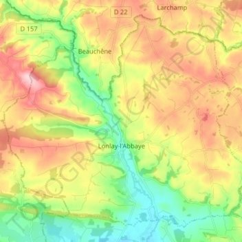
Nom : Carte topographique Lonlay-l'Abbaye, altitude, relief.
Altitude moyenne : 214 m
Altitude minimum : 123 m
Altitude maximum : 326 m
La topographie est très marquée et contribue fortement à la définition de l’urbanisation du territoire. Les altitudes varient de 129 m au sud du territoire à 320 m NGF à hauteur du Haut du Bois, soit un dénivelé proche de 200 mètres. Le centre bourg est implanté dans le fonds de la vallée de l’Égrenne avec une orientation nord-sud. En amont du bourg, cette vallée apparaît relativement encaissée et a tendance à s’ouvrir au sud du territoire.
Autres cartes topographiques
Cliquez sur une carte pour visualiser sa topographie, son altitude et son relief.
Moutiers-au-Perche
Moutiers-au-Perche, Mortagne-au-Perche, Orne, Normandie, France métropolitaine, 61110, France
Altitude moyenne : 199 m
Larchamp
France > Normandie > Orne > Tinchebray-Bocage
Larchamp, Tinchebray-Bocage, Argentan, Orne, Normandie, France métropolitaine, 61800, France
Altitude moyenne : 254 m
La Lande-Patry
France > Normandie > Orne > La Lande-Patry
La Lande-Patry, Argentan, Orne, Normandie, France métropolitaine, 61100, France
Altitude moyenne : 200 m
La Perrière
France > Normandie > Orne > Belforêt-en-Perche
La Perrière, Belforêt-en-Perche, Mortagne-au-Perche, Orne, Normandie, France métropolitaine, 61360, France
Altitude moyenne : 174 m