
Carte topographique Glenwood Springs
Carte interactive
Cliquez sur la carte pour afficher l’altitude.
À propos de cette carte
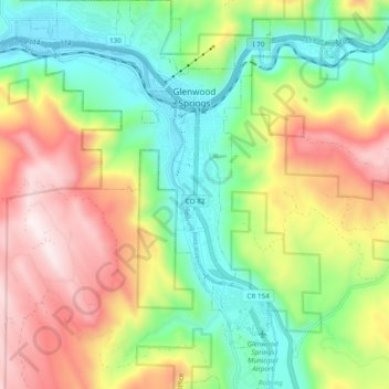
Nom : Carte topographique Glenwood Springs, altitude, relief.
Altitude moyenne : 2’081 m
Altitude minimum : 1’736 m
Altitude maximum : 2’580 m
Local food production has seen a revival in recent years. While not as consistently fecund as the extensive agricultural and viticultural areas at lower altitude such as Palisade, most types of fruit and vegetable grow well in the light and soil if well watered. Stonefruit such as cherries, peaches, and plums, pomaceous fruit such as apples and pears, and grapes are suited to the climate and terrain.
Autres cartes topographiques
Cliquez sur une carte pour visualiser sa topographie, son altitude et son relief.
Battlement Mesa
United States > Colorado > Garfield County
Battlement Mesa, Garfield County, Colorado, 81635, United States
Altitude moyenne : 1’806 m
Douglas Pass
United States > Colorado > Garfield County
Douglas Pass, Garfield County, Colorado, United States
Altitude moyenne : 2’435 m
Carbondale
United States > Colorado > Garfield County
Carbondale, Garfield County, Colorado, United States
Altitude moyenne : 1’919 m
New Castle
United States > Colorado > Garfield County
New Castle, Garfield County, Colorado, 81647, United States
Altitude moyenne : 1’810 m
Rifle
United States > Colorado > Garfield County
Rifle, Garfield County, Colorado, 81650, United States
Altitude moyenne : 1’731 m