
Carte topographique Lough Derravaragh
Carte interactive
Cliquez sur la carte pour afficher l’altitude.
À propos de cette carte
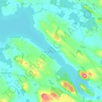
Nom : Carte topographique Lough Derravaragh, altitude, relief.
Altitude moyenne : 85 m
Altitude minimum : 55 m
Altitude maximum : 206 m
Autres cartes topographiques
Cliquez sur une carte pour visualiser sa topographie, son altitude et son relief.
Lough Bane
Lough Bane, Crosskeys ED, The Municipal District of Kells, County Westmeath, County Meath, Leinster, Ireland
Altitude moyenne : 130 m
Rathwire
Rathwire, The Municipal District of Mullingar — Kinnegad, County Westmeath, Leinster, Ireland
Altitude moyenne : 94 m
Ardnurcher
Ardnurcher, Streamstown ED, The Municipal District of Athlone — Moate, County Westmeath, Leinster, Ireland
Altitude moyenne : 71 m
Athlone
Ireland > County Westmeath > Athlone
Athlone, The Municipal District of Athlone — Moate, County Westmeath, Leinster, N37 N1F2, Ireland
Altitude moyenne : 44 m
Fore
Fore, The Municipal District of Mullingar — Kinnegad, County Westmeath, Leinster, N91 TY06, Ireland
Altitude moyenne : 110 m
Lough Sewdy
Lough Sewdy, Ballymore ED, The Municipal District of Athlone — Moate, County Westmeath, Leinster, Ireland
Altitude moyenne : 86 m
Kilbixy
Kilbixy, Kilbixy ED, The Municipal District of Athlone — Moate, County Westmeath, Leinster, Ireland
Altitude moyenne : 67 m
Ballyloughloe
Ballyloughloe, The Municipal District of Athlone — Moate, County Westmeath, Leinster, N37 C4A0, Ireland
Altitude moyenne : 72 m
Athlone
Athlone, County Westmeath, Leinster, Ireland
Altitude moyenne : 43 m
Tyrrellspass
Tyrrellspass, The Municipal District of Athlone — Moate, County Westmeath, Leinster, Ireland
Altitude moyenne : 100 m
Dysart
Dysart, Bracklin ED, The Municipal District of Mullingar — Kinnegad, County Westmeath, Leinster, Ireland
Altitude moyenne : 84 m
Castletown Geoghegan
Castletown Geoghegan, Castletown ED, The Municipal District of Athlone — Moate, County Westmeath, Leinster, Ireland
Altitude moyenne : 96 m
Streamstown
Streamstown, The Municipal District of Athlone — Moate, County Westmeath, Leinster, Ireland
Altitude moyenne : 105 m
Glassan
Glassan, Glassan ED, The Municipal District of Athlone — Moate, County Westmeath, Leinster, Ireland
Altitude moyenne : 57 m
Lough Bane
Lough Bane, Knockarrow ED, The Municipal District of Mullingar — Kinnegad, County Westmeath, Leinster, Ireland
Altitude moyenne : 66 m
Rochfortbridge
Rochfortbridge, The Municipal District of Mullingar — Kinnegad, County Westmeath, Leinster, N91 AE6P, Ireland
Altitude moyenne : 90 m
Castletown
Castletown, The Municipal District of Mullingar — Kinnegad, County Westmeath, Leinster, A82 F8D2, Ireland
Altitude moyenne : 88 m
Moate
Moate, The Municipal District of Athlone — Moate, County Westmeath, Leinster, N37 WK44, Ireland
Altitude moyenne : 76 m
Toberclare
Toberclare, Auburn ED, The Municipal District of Athlone — Moate, County Westmeath, Leinster, Ireland
Altitude moyenne : 62 m
The Municipal District of Mullingar — Kinnegad
The Municipal District of Mullingar — Kinnegad, County Westmeath, Leinster, Ireland
Altitude moyenne : 90 m
Castlelost
Castlelost, Castlelost ED, The Municipal District of Mullingar — Kinnegad, County Westmeath, Leinster, Ireland
Altitude moyenne : 93 m
Banagher
Banagher, Huntingdon ED, The Municipal District of Mullingar — Kinnegad, County Westmeath, Leinster, Ireland
Altitude moyenne : 96 m
Garrycastle
Garrycastle, Athlone East Rural ED, The Municipal District of Athlone — Moate, County Westmeath, Leinster, N37 EE71, Ireland
Altitude moyenne : 49 m
Mullingar
Ireland > County Westmeath > Mullingar
Mullingar, The Municipal District of Mullingar — Kinnegad, County Westmeath, Leinster, N91 FY58, Ireland
Altitude moyenne : 101 m
Mullingar
Mullingar, The Municipal District of Mullingar — Kinnegad, County Westmeath, Leinster, Ireland
Altitude moyenne : 99 m
Adamstown
Adamstown, Churchtown ED, The Municipal District of Athlone — Moate, County Westmeath, Leinster, Ireland
Altitude moyenne : 128 m
Kiltotan and Collinstown
Kiltotan and Collinstown, Castlelost ED, The Municipal District of Mullingar — Kinnegad, County Westmeath, Leinster, Ireland
Altitude moyenne : 97 m
Lough Owel
Lough Owel, The Municipal District of Mullingar — Kinnegad, County Westmeath, Leinster, Ireland
Altitude moyenne : 105 m
Hill of Uisneach
Hill of Uisneach, R390, Ballymorin ED, The Municipal District of Athlone — Moate, County Westmeath, Leinster, Ireland
Altitude moyenne : 128 m
Kilbeggan
Kilbeggan, Kilbeggan ED, The Municipal District of Athlone — Moate, County Westmeath, Leinster, Ireland
Altitude moyenne : 71 m
Ballynaskeagh
Ballynaskeagh, Clonarney ED, The Municipal District of Mullingar — Kinnegad, County Westmeath, Leinster, Ireland
Altitude moyenne : 90 m
Clonmore
Clonmore, Castledaly ED, The Municipal District of Athlone — Moate, County Westmeath, Leinster, Ireland
Altitude moyenne : 54 m
Balrath
Balrath, Churchtown ED, The Municipal District of Athlone — Moate, County Westmeath, Leinster, Ireland
Altitude moyenne : 128 m
Paslicktown
Paslicktown, Belvidere ED, The Municipal District of Mullingar — Kinnegad, County Westmeath, Leinster, Ireland
Altitude moyenne : 104 m
Ballykilroe
Ballykilroe, Ballynagore ED, The Municipal District of Athlone — Moate, County Westmeath, Leinster, Ireland
Altitude moyenne : 89 m
Griffinstown
Griffinstown, Griffinstown ED, The Municipal District of Mullingar — Kinnegad, County Westmeath, Leinster, Ireland
Altitude moyenne : 83 m
Ballinea
Ireland > County Westmeath > Ballinea
Ballinea, The Municipal District of Mullingar — Kinnegad, County Westmeath, Leinster, Ireland
Altitude moyenne : 100 m
Clonmoyle
Clonmoyle, Russellstown ED, The Municipal District of Mullingar — Kinnegad, County Westmeath, Leinster, Ireland
Altitude moyenne : 108 m
Simonstown
Ireland > County Westmeath > Simonstown
Simonstown, Coole ED, The Municipal District of Mullingar — Kinnegad, County Westmeath, Leinster, Ireland
Altitude moyenne : 80 m
Multyfarnham
Ireland > County Westmeath > Multyfarnham
Multyfarnham, The Municipal District of Mullingar — Kinnegad, County Westmeath, Leinster, N91 Y293, Ireland
Altitude moyenne : 88 m
Milltown
Milltown, Milltown ED, The Municipal District of Mullingar — Kinnegad, County Westmeath, Leinster, Ireland
Altitude moyenne : 84 m
Killucan
Ireland > County Westmeath > Killucan
Killucan, The Municipal District of Mullingar — Kinnegad, County Westmeath, Leinster, Ireland
Altitude moyenne : 97 m
The Municipal District of Athlone — Moate
The Municipal District of Athlone — Moate, County Westmeath, Leinster, Ireland
Altitude moyenne : 69 m
Kiltoom
Kiltoom, Coolure ED, The Municipal District of Mullingar — Kinnegad, County Westmeath, Leinster, Ireland
Altitude moyenne : 80 m
Muckanagh
Muckanagh, Muckanagh ED, The Municipal District of Athlone — Moate, County Westmeath, Leinster, Ireland
Altitude moyenne : 38 m
Kinnegad
Ireland > County Westmeath > Kinnegad
Kinnegad, Kinnegad ED, The Municipal District of Mullingar — Kinnegad, County Westmeath, Leinster, Ireland
Altitude moyenne : 75 m