
Carte topographique Denny
Carte interactive
Cliquez sur la carte pour afficher l’altitude.
À propos de cette carte
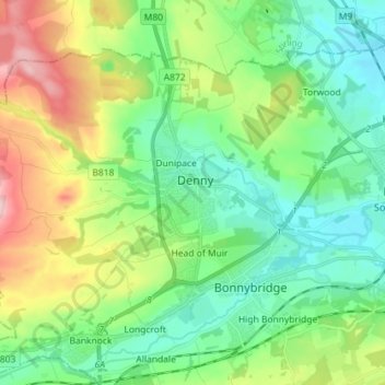
Nom : Carte topographique Denny, altitude, relief.
Lieu : Denny, Falkirk, Scotland, FK6 6EL, United Kingdom (55.98374 -3.94820 56.06374 -3.86820)
Altitude moyenne : 86 m
Altitude minimum : 10 m
Altitude maximum : 253 m
Autres cartes topographiques
Cliquez sur une carte pour visualiser sa topographie, son altitude et son relief.
Union Canal
United Kingdom > Scotland > Falkirk
Canal commences from the sixteenth lock of the Forth and Clyde Navigation, about two miles west of Falkirk, in the county of Sterling , whence it takes an eastwardly course on the south side of the above-mentioned town, by some collieries; thence, through Black Hill Tunnel, and across the Glen Water, on which…
Altitude moyenne : 136 m