
Carte topographique The Birket
Carte interactive
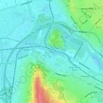
Cliquez sur la carte pour afficher l’altitude.
À propos de cette carte
Nom : Carte topographique The Birket, altitude, relief.
Altitude moyenne : 15 m
Altitude minimum : -1 m
Altitude maximum : 68 m
Autres cartes topographiques
Cliquez sur une carte pour visualiser sa topographie, son altitude et son relief.
Birkenhead Park
United Kingdom > England > Wirral
Birkenhead Park, Claughton, Wirral, North West England, England, United Kingdom
Altitude moyenne : 23 m
Prenton Brook
United Kingdom > England > Wirral
Prenton Brook, Wirral, North West England, England, CH43 3HQ, United Kingdom
Altitude moyenne : 38 m
Greasby Brook
United Kingdom > England > Wirral
Greasby Brook, Wirral, North West England, England, CH48 1PT, United Kingdom
Altitude moyenne : 19 m
Arrowe Brook
United Kingdom > England > Wirral
Arrowe Brook, Wirral, North West England, England, CH46 5NP, United Kingdom
Altitude moyenne : 17 m
The Beacons
United Kingdom > England > Wirral
The Beacons, Beacon Lane, Woodchurch, Wirral, North West England, England, CH60 0BY, United Kingdom
Altitude moyenne : 56 m