
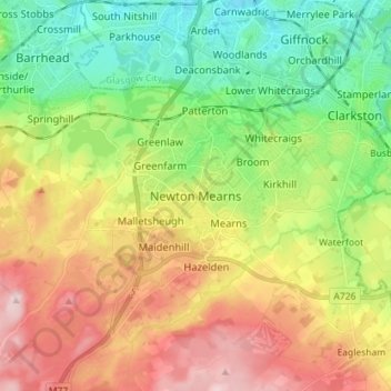
Carte topographique Newton Mearns
Carte interactive
Cliquez sur la carte pour afficher l’altitude.
À propos de cette carte
Nom : Carte topographique Newton Mearns, altitude, relief.
Altitude moyenne : 127 m
Altitude minimum : 20 m
Altitude maximum : 274 m
Autres cartes topographiques
Cliquez sur une carte pour visualiser sa topographie, son altitude et son relief.
Eaglesham
United Kingdom > Scotland > East Renfrewshire
Eaglesham, East Renfrewshire, Scotland, G76 0LG, United Kingdom
Altitude moyenne : 172 m
Busby
United Kingdom > Scotland > East Renfrewshire
Busby, East Renfrewshire, Scotland, G76 8JZ, United Kingdom
Altitude moyenne : 104 m
Clarkston
United Kingdom > Scotland > East Renfrewshire
Clarkston, East Renfrewshire, Scotland, G76 7AT, United Kingdom
Altitude moyenne : 94 m
Dams to Darnley Country Park
United Kingdom > Scotland > East Renfrewshire > Barrhead
Dams to Darnley Country Park, Barrhead, East Renfrewshire, Scotland, United Kingdom
Altitude moyenne : 77 m
Barrhead
United Kingdom > Scotland > East Renfrewshire
Barrhead, East Renfrewshire, Scotland, G78 1SD, United Kingdom
Altitude moyenne : 93 m
Neilston
United Kingdom > Scotland > East Renfrewshire
Neilston, East Renfrewshire, Scotland, G78 3NJ, United Kingdom
Altitude moyenne : 149 m
Uplawmoor
United Kingdom > Scotland > East Renfrewshire
Uplawmoor, East Renfrewshire, Scotland, G78 4AN, United Kingdom
Altitude moyenne : 181 m
Thornliebank
United Kingdom > Scotland > East Renfrewshire > Thornliebank
Thornliebank, East Renfrewshire, Scotland, G46 7RX, United Kingdom
Altitude moyenne : 59 m
Rouken Glen Park
United Kingdom > Scotland > East Renfrewshire > Thornliebank
Rouken Glen Park, Woodlands, Thornliebank, East Renfrewshire, Scotland, United Kingdom
Altitude moyenne : 65 m
Giffnock
United Kingdom > Scotland > East Renfrewshire
Giffnock, East Renfrewshire, Scotland, G46 6XW, United Kingdom
Altitude moyenne : 65 m